
Panama-Canal-rough-diagram-quick.jpg (560×540 điểm ảnh, kích thước tập tin: 57 kB, kiểu MIME: image/jpeg)
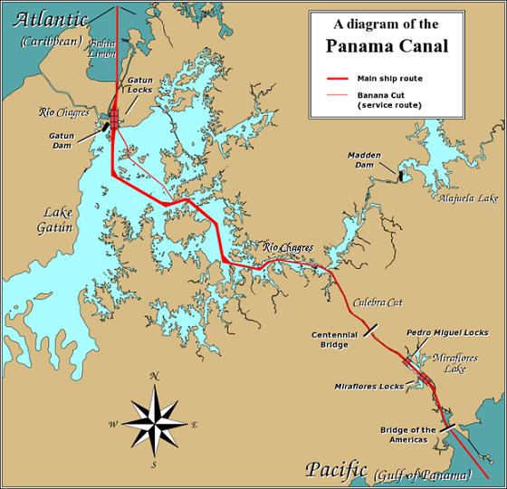
| Miêu tảPanama-Canal-rough-diagram-quick.jpg | English: A diagram illustrating the layout of the Panama Canal (in quick JPEG format, auto-resizes to fit). Due to the shape of the Isthmus of Panama, the Pacific end of the canal is actually the south-east end, and the Caribbean / Atlantic end is at the north-west. From the Pacific side, the Miraflores and Pedro Miguel locks (with two and one stages respectively) lead up to the highest level of the canal, 26 metres (85 feet) above sea level. The Culebra Cut (or Gaillard Cut) leads to Gatún Lake, created by damming the Chagres River; then the Gatún Locks lead back down to sea level in Limón Bay. The heavy red line shows the ship route. The narrower red line in Gatún Lake is the Banana Cut, a shortcut used by canal boats and yachts. |
| Ngày | |
| Nguồn gốc | Source URL: Image:Panama_Canal_Rough_Diagram.png (GFDL file, reduced/retouched, saved JPEG format (5x faster than PNG), intended for use in frequently-read Wiki articles). |
| Tác giả | User:Johantheghost (JPEG version by Wikid77) |
 | Hình ảnh thuộc thể loại "transport map" cần được vẽ lại bằng đồ họa vector theo định dạng tập tin SVG. Để biết ưu điểm của định dạng này, hãy đọc Commons:Media for cleanup. Nếu tập tin này đã có SVG, xin hãy tải lên đây rồi thay bản mẫu này bằng {{vector version available|tên hình mới.svg}}. |
 | This transport map image was uploaded in the JPEG format even though it consists of non-photographic data. This information could be stored more efficiently or accurately in the PNG or SVG format. If possible, please upload a PNG or SVG version of this image without compression artifacts, derived from a non-JPEG source (or with existing artifacts removed). After doing so, please tag the JPEG version with {{Superseded|NewImage.ext}} and remove this tag. This tag should not be applied to photographs or scans. If this image is a diagram or other image suitable for vectorisation, please tag this image with {{Convert to SVG}} instead of {{BadJPEG}}. If not suitable for vectorisation, use {{Convert to PNG}}. For more information, see {{BadJPEG}}. |  |
 | Bạn có quyền sao chép, phân phối và/hoặc sửa đổi tài liệu này theo những điều khoản được quy định trong Giấy phép Tài liệu Tự do GNU, phiên bản 1.2 hoặc các phiên bản mới hơn được Quỹ Phần mềm Tự do; quy định; ngoại trừ những phần không được sửa đổi, bìa trước và bìa sau. Bạn có thể xem giấy phép nói trên ở phần Giấy phép Tài liệu Tự do GNU.http://www.gnu.org/copyleft/fdl.htmlGFDLGNU Free Documentation Licensetruetrue |
| Tập tin này được phát hành theo Giấy phép Creative Commons Ghi công - Chia sẻ tương tự 3.0 Chưa chuyển đồi | ||
| ||
| Thẻ quyền này được thêm vào tập tin trong khi cập nhật giấy phép GFDL.http://creativecommons.org/licenses/by-sa/3.0/CC BY-SA 3.0Creative Commons Attribution-Share Alike 3.0truetrue |
Nhấn vào ngày/giờ để xem nội dung tập tin tại thời điểm đó.
| Ngày/giờ | Hình xem trước | Kích cỡ | Thành viên | Miêu tả | |
|---|---|---|---|---|---|
| hiện tại | 17:28, ngày 26 tháng 12 năm 2006 | | 560×540 (57 kB) | Wikid77 | == Summary == A diagram illustrating the layout of the Panama Canal (in quick JPEG format, auto-resizes to fit). Due to the shape of the Isthmus of Panama, the Pacific |
Những wiki sau đang sử dụng tập tin này:
Tập tin này chứa thông tin bổ sung, có thể được thêm từ máy ảnh kỹ thuật số hoặc máy quét được sử dụng để tạo hoặc số hóa tệp.
Nếu tập tin đã được sửa đổi so với trạng thái ban đầu, một số chi tiết có thể không phản ánh đầy đủ tập tin đã sửa đổi.
| _error | 0 |
|---|