

Buong resolusyon ((2,552 × 1,442 pixel, laki ng talaksan: 6 MB, uri ng MIME: image/png))
| | Ito ay isang talaksan mula sa Wikimedia Commons. Makikita sa ibaba ang impormasyon mula sa pahina ng paglalarawan nito roon. |
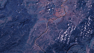
| PaglalarawanSatellite Image of Tahihe.png | English: Satellite Image of Taihe County, China 中文:泰和县卫星图像 |
| Pinanggalingan | NASA Landsat7 |
| May-akda | NASA |
| Public domainPublic domainfalsefalse |
| This file is in the public domain in the United States because it was solely created by NASA. NASA copyright policy states that "NASA material is not protected by copyright unless noted". (See Template:PD-USGov, NASA copyright policy page or JPL Image Use Policy.) | ||
 | Warnings:
|
Pindutin ang araw/oras upang makita kung papaano ang itsura ng talaksan noong oras na iyon.
| Araw/Oras | Thumbnail | Mga dimensiyon | tagagamit | Kumento | |
|---|---|---|---|---|---|
| ngayon | 13:31, 24 Marso 2009 | | 2,552 × 1,442 (6 MB) | Camphora | 投影由 Geographic 改为 UTM |
| 01:31, 13 Marso 2009 |  | 2,552 × 1,336 (6.77 MB) | Camphora | 调整曝光 | |
| 07:26, 1 Marso 2009 |  | 2,552 × 1,336 (5.13 MB) | Camphora | {{Information |Description={{en|1=Satellite Image of Taihe County, China }} {{zh|1=泰和县卫星图像}} |Source=NASA Landsat7 |Author=NASA |Date= |Permission= |other_versions= }} Category:satellites Category:Geography of Jiangxi [[Category:Land |
Nakaturo sa talaksan na ito ang mga sumusunod na mga pahina:
Ginagamit ng mga sumusunod na wiki ang file na ito: