Vanne (river)
The Vanne is a river in eastern France that flows through the Aube and Yonne departments, in the Grand Est and Bourgogne-Franche-Comté regions. The Vanne is a right tributary of the Yonne river.
| Vanne | |
|---|---|
 | |
.png) | |
| Location | |
| Country | France |
| Physical characteristics | |
| Source | |
| - location | Aube department |
| Mouth | |
| - location | Yonne |
| - coordinates | 48°11′24″N 3°16′8″E / 48.19000°N 3.26889°E |
| Length | 59 km (37 mi) |
| Basin size | 990 km2 (380 sq mi) |
| Basin features | |
| Progression | Yonne→ Seine→ English Channel |
Geography
The Vanne river has a length of 59 km (36.7 mi),[1] and a drainage basin with an area of approximately 990 km2 (382 sq mi).
Its average yearly discharge (volume of water which passes through a section of the river per unit of time) is 5.33 m3/s (188 cu ft/s) at Pont-sur-Vanne in the Yonne department.[2]
 |
Course
The watershed of the Vanne is in the Aube and Yonne departments. It starts, an altitude of 145 m (475.7 ft), under the church of the commune of Fontvannes. a small town that is at about 17 km (11 mi) to the west of the city of Troyes, the capital of the Aube department.[3] It then flows to the southwest and gets into the Yonne department.
In Sens. the Vanne joins, by its right side, the Yonne river at an altitude of 65 m (213.3 ft).[4]
The Vanne flows through the following communes:
- Aube department
- Yonne department
Main tributaries
Most of the tributaries of the Vanne are small streams; the only important tributaries (all of them left tributaries) are:
- Ancre - 15.9 km
- Nosle - 13.4 km
- Cérilly - 15.2 km
Gallery
 The source of the Vanne in Fontvannes.
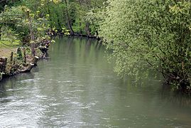 The Vanne in Bagneaux.
 Bridge over the Vanne in Malay-le-Petit.
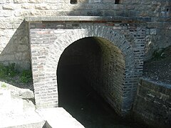
 Aqueduct of the Vanne in Pont-sur-Vanne.


Related pages
References
Other websites
- Banque Hydro - Station H2622010 - La Vanne à Pont-sur-Vanne (Synthèse) Archived 2015-02-19 at the Wayback Machine (in French)