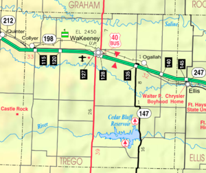
Trego County, Kansas
county in Kansas, United States
Trego County (standard abbreviation: TR) is a county in the U.S. state of Kansas. In 2020, 2,808 people lived there.[2] Its county seat is WaKeeney. WaKeeney is also the biggest city in Trego County.[3]
Trego County | |
|---|---|
 Trego County Courthouse in WaKeeney (2017) | |
 Location within the U.S. state of Kansas | |
 Kansas's location within the U.S. | |
| Coordinates: 39°00′30″N 100°03′54″W / 39.0083°N 100.065°W | |
| Country | |
| State | |
| Founded | June 21, 1879 |
| Named for | Edgar Poe Trego[1] |
| Seat | WaKeeney |
| Largest city | WaKeeney |
| Area | |
| • Total | 900 sq mi (2,000 km2) |
| • Land | 889 sq mi (2,300 km2) |
| • Water | 10 sq mi (30 km2) 1.1% |
| Population | |
| • Total | 2,808 |
| • Density | 3.2/sq mi (1.2/km2) |
| Time zone | UTC−6 (Central) |
| • Summer (DST) | UTC−5 (CDT) |
| Congressional district | 1st |
| Website | tregocountyks |
History
19th century
In 1879, Trego County was created.
Geography
The U.S. Census Bureau says that the county has a total area of 900 square miles (2,300 km2). Of that, 889 square miles (2,300 km2) is land and 10 square miles (26 km2) (1.1%) is water.[4]
Major highways
 Interstate 70
 U.S. Route 40
 U.S. Route 283
 K-147
K-147
People
| Historical population | |||
|---|---|---|---|
| Census | Pop. | %± | |
| 1870 | 166 | — | |
| 1880 | 2,535 | 1,427.1% | |
| 1890 | 2,535 | 0.0% | |
| 1900 | 2,722 | 7.4% | |
| 1910 | 5,398 | 98.3% | |
| 1920 | 5,880 | 8.9% | |
| 1930 | 6,470 | 10.0% | |
| 1940 | 5,822 | −10.0% | |
| 1950 | 5,868 | 0.8% | |
| 1960 | 5,473 | −6.7% | |
| 1970 | 4,436 | −18.9% | |
| 1980 | 4,165 | −6.1% | |
| 1990 | 3,694 | −11.3% | |
| 2000 | 3,319 | −10.2% | |
| 2010 | 3,001 | −9.6% | |
| 2020 | 2,808 | −6.4% | |
| U.S. Decennial Census[5] 1790-1960[6] 1900-1990[7] 1990-2000[8] 2010-2020[2] | |||

Government
Presidential elections
Republican candidates often win Trego County. The last time a democratic candidate has won this county was in 1964.
Presidential Elections Results
| Year | Republican | Democratic | Third Parties |
|---|---|---|---|
| 2020 | 83.6% 1,363 | 14.8% 242 | 1.5% 25 |
| 2016 | 82.8% 1,227 | 13.4% 198 | 3.9% 57 |
| 2012 | 79.9% 1,261 | 18.4% 291 | 1.7% 27 |
| 2008 | 73.3% 1,225 | 25.1% 420 | 1.6% 26 |
| 2004 | 72.7% 1,225 | 25.7% 434 | 1.6% 27 |
| 2000 | 66.4% 1,220 | 28.1% 516 | 5.5% 101 |
| 1996 | 61.1% 1,205 | 27.8% 548 | 11.1% 219 |
| 1992 | 38.0% 727 | 31.8% 608 | 30.2% 577 |
| 1988 | 53.5% 979 | 43.4% 795 | 3.1% 57 |
| 1984 | 70.4% 1,491 | 28.2% 598 | 1.4% 29 |
| 1980 | 65.4% 1,340 | 25.5% 523 | 9.0% 185 |
| 1976 | 49.6% 1,025 | 48.5% 1,003 | 1.9% 40 |
| 1972 | 66.9% 1,369 | 30.4% 621 | 2.7% 56 |
| 1968 | 58.7% 1,211 | 30.2% 623 | 11.1% 230 |
| 1964 | 45.1% 974 | 54.4% 1,177 | 0.5% 11 |
| 1960 | 61.8% 1,426 | 37.9% 875 | 0.4% 8 |
| 1956 | 69.4% 1,668 | 30.2% 726 | 0.4% 9 |
| 1952 | 75.6% 1,915 | 24.0% 608 | 0.4% 10 |
| 1948 | 51.8% 1,237 | 46.8% 1,117 | 1.4% 33 |
| 1944 | 62.0% 1,459 | 37.5% 883 | 0.5% 12 |
| 1940 | 57.6% 1,571 | 41.8% 1,140 | 0.6% 17 |
| 1936 | 36.0% 1,012 | 63.4% 1,783 | 0.6% 16 |
| 1932 | 33.8% 918 | 64.4% 1,751 | 1.8% 50 |
| 1928 | 57.7% 1,359 | 41.7% 982 | 0.6% 13 |
| 1924 | 58.1% 1,121 | 20.7% 399 | 21.2% 408 |
| 1920 | 75.0% 1,299 | 22.8% 395 | 2.1% 37 |
| 1916 | 42.1% 867 | 53.1% 1,094 | 4.9% 100 |
| 1912 | 14.3% 160 | 40.2% 449 | 45.4% 507[a] |
| 1908 | 54.8% 617 | 40.6% 458 | 4.6% 52 |
| 1904 | 60.8% 526 | 30.5% 264 | 8.7% 75 |
| 1900 | 48.4% 360 | 48.5% 361 | 3.1% 23 |
| 1896 | 42.7% 256 | 56.8% 340 | 0.5% 3 |
| 1892 | 50.5% 309 | 49.5% 303 | |
| 1888 | 63.9% 477 | 29.5% 220 | 6.7% 50 |
Education
Unified school districts
Communities

Cities
- Collyer
- WaKeeney
References
- Notes
More reading
- Standard Atlas of Trego County, Kansas; Geo. A. Ogle & Co; 57 pages; 1906.
Other websites

Wikimedia Commons has media related to Trego County, Kansas.
- County
- Maps
🔥 Top keywords: Main PageSpecial:SearchSupreme Court of the United StatesList of UEFA European Championship finalsWikipedia:AboutList of U.S. statesHelp:ContentsHelp:IntroductionKnights of the Round TableList of Disney moviesBlackSpecial:RecentChangesGodzilla X Kong: The New EmpireList of people who have walked on the MoonList of U.S. states and territories by time zoneUnited StatesThe Garfield MovieEducation24-hour clockEid al-AdhaGolden EdgeQueen (band)List of countries by continentsAviciiBig Mac IndexAdolf Hitler UunonaUmro Ayyar - A New BeginningMurder of Junko FurutaHelp:Authority controlCristiano RonaldoBismillahir Rahmanir Raheem19 Kids and CountingSOLID (object-oriented design)Jude BellinghamXXXTentacionLisa SparxxxPeriodic tableList of fruitsBTS


