Galápagos Province
province of Ecuador
Galápagos (Spanish pronunciation: [ɡaˈlapaɣos]) is a province of Ecuador in the country's Insular region. It is located 1,000 km (620 mi) off the western coast of the mainland. The capital is Puerto Baquerizo Moreno.
Galápagos Province Provincia de Galápagos | |
|---|---|
 Satellite photo of the Galapagos islands | |
| Nickname: Archipelago of Galapagos | |
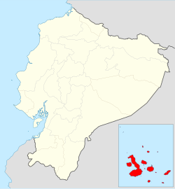
 Location of Galápagos Province | |
 Cantons of Galápagos Province | |
| Coordinates: 0°33′37″S 91°2′27″W / 0.56028°S 91.04083°W | |
| Country | |
| Created | February 18, 1973 |
| Named for | Galápagos Islands |
| Capital | Puerto Baquerizo Moreno |
| Cantons | List of cantons
|
| Government | |
| • Governor | Jorge Torres (2008-) |
| Area | |
| • Province | 45,000 km2 (17,000 sq mi) |
| • Land | 8,010 km2 (3,090 sq mi) |
| Highest elevation | 1,710 m (5,610 ft) |
| Lowest elevation | 0 m (0 ft) |
| Population (2010 census) | |
| • Province | 25,124 |
| • Density | 0.56/km2 (1.4/sq mi) |
| • Urban | 7,475 |
| Time zone | UTC-6 (GALT) |
| Area code | (0)5 |
| ISO 3166 code | EC-W |
| Vehicle registration | W |
| Languages | Spanish and English |
| HDI (2017) | 0.801[1] very high · 2nd |
| Website | www |
The province has the Galápagos Islands, a group of tiny volcanic islands that sit on the equator.
Political divisions
The province is divided in three cantons, each with a number of islands. They are:
| Canton | Pop. | Area (km²) | Capital | Principal islands |
|---|---|---|---|---|
| Isabela | 1,780 | 5,367 | Puerto Villamil | Darwin, Fernandina, Isabela, Wolf |
| San Cristóbal | 6,142 | 849 | Puerto Baquerizo Moreno | Española, Floreana, Genovesa, San Cristóbal, Santa Fe |
| Santa Cruz | 11,262 | 1,794 | Puerto Ayora | Baltra, Bartolomé, Marchena, North Seymour, Pinta, Pinzón, Rábida, Santa Cruz, Santiago |
| Galápagos | 19,184 | 8,010 | Puerto Baquerizo Moreno | [2] |
References
🔥 Top keywords: Main PageSpecial:SearchSupreme Court of the United StatesList of UEFA European Championship finalsWikipedia:AboutList of U.S. statesHelp:ContentsHelp:IntroductionKnights of the Round TableList of Disney moviesBlackSpecial:RecentChangesGodzilla X Kong: The New EmpireList of people who have walked on the MoonList of U.S. states and territories by time zoneUnited StatesThe Garfield MovieEducation24-hour clockEid al-AdhaGolden EdgeQueen (band)List of countries by continentsAviciiBig Mac IndexAdolf Hitler UunonaUmro Ayyar - A New BeginningMurder of Junko FurutaHelp:Authority controlCristiano RonaldoBismillahir Rahmanir Raheem19 Kids and CountingSOLID (object-oriented design)Jude BellinghamXXXTentacionLisa SparxxxPeriodic tableList of fruitsBTS

