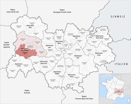
Arrondissement of Issoire
The arrondissement of Issoire is an arrondissement of France. It is part of the Puy-de-Dôme département, Auvergne-Rhône-Alpes region. Its capital, and a subprefecture of the department, is the city of Issoire.
Issoire | |
|---|---|
 Location within the region Auvergne-Rhône-Alpes | |
| Country | France |
| Region | Auvergne-Rhône-Alpes |
| Department | Puy-de-Dôme |
| No. of communes | 134 |
| Subprefecture | Issoire |
| Area | 2,296.7 km2 (886.8 sq mi) |
| Population (Jan. 2019)[1] | 79,068 |
| INSEE code | 633 |
History
When the Puy-de-Dôme department was created in 1790, the arrondissement of Issoire was part of that original department.[2]
Geography
The arrondissement of Issoire is in the southwest of the department and borders to the north with the arrondissement of Clermont-Ferrand, to the east with the arrondissement of Ambert, to the southeast with the Haute-Loire department, to the south with the Cantal department, and to the west and northwest with the arrondissement of Riom.
The arrondissement of Issoire is the second largest arrondissement of the department, with an area of 1,819.6 km2 (702.6 sq mi).[3] It has a population of 62,931 inhabitants and a density of 34.6 inhabitants/km².[4]
Composition
Cantons
After the reorganisation of the cantons in France,[5] cantons are not subdivisions of the arrondissements so they could have communes that belong to different arrondissements.
In the arrondissement of Issoire there are 5 cantons:
- Brassac-les-Mines (6306)
- Issoire (6318)
- Orcines (6323) (partly)
- Le Sancy (6329) (partly)
- Vic-le-Comte (6331) (partly)
Communes
The arrondissement of Issoire has 135 communes; they are (with their INSEE codes):[6]
- Antoingt (63005)
- Anzat-le-Luguet (63006)
- Apchat (63007)
- Ardes (63009)
- Augnat (63017)
- Aulhat-Flat (63160)
- Aurières (63020)
- Auzat-la-Combelle (63022)
- Avèze (63024)
- Bagnols (63028)
- Bansat (63029)
- Beaulieu (63031)
- Bergonne (63036)
- Besse-et-Saint-Anastaise (63038)
- Boudes (63046)
- La Bourboule (63047)
- Brassac-les-Mines (63050)
- Brenat (63051)
- Le Breuil-sur-Couze (63052)
- Le Broc (63054)
- Ceyssat (63071)
- Chadeleuf (63073)
- Chalus (63074)
- Chambon-sur-Lac (63077)
- Chaméane (63078)
- Champagnat-le-Jeune (63079)
- Champeix (63080)
- La Chapelle-Marcousse (63087)
- La Chapelle-sur-Usson (63088)
- Charbonnier-les-Mines (63091)
- Chassagne (63097)
- Chastreix (63098)
- Chidrac (63109)
- Clémensat (63111)
- Collanges (63114)
- Compains (63117)
- Coudes (63121)
- Courgoul (63122)
- Creste (63127)
- Cros (63129)
- Dauzat-sur-Vodable (63134)
- Égliseneuve-d'Entraigues (63144)
- Égliseneuve-des-Liards (63145)
- Espinchal (63153)
- Esteil (63156)
- Gelles (63163)
- Gignat (63166)
- La Godivelle (63169)
- Grandeyrolles (63172)
- Heume-l'Église (63176)
- Issoire (63178)
- Jumeaux (63182)
- Labessette (63183)
- Lamontgie (63185)
- Laqueuille (63189)
- Larodde (63190)
- Ludesse (63199)
- Madriat (63202)
- Mareugheol (63209)
- Mazaye (63219)
- Mazoires (63220)
- Meilhaud (63222)
- Montaigut-le-Blanc (63234)
- Mont-Dore (63236)
- Montpeyroux (63241)
- Moriat (63242)
- Murat-le-Quaire (63246)
- Murol (63247)
- Nébouzat (63248)
- Neschers (63250)
- Nonette-Orsonnette (63255)
- Olby (63257)
- Orbeil (63261)
- Orcival (63264)
- Pardines (63268)
- Parent (63269)
- Parentignat (63270)
- Perpezat (63274)
- Perrier (63275)
- Peslières (63277)
- Picherande (63279)
- Plauzat (63282)
- Les Pradeaux (63287)
- Rentières (63299)
- Roche-Charles-la-Mayrand (63303)
- Rochefort-Montagne (63305)
- Saint-Alyre-ès-Montagne (63313)
- Saint-Babel (63321)
- Saint-Bonnet-près-Orcival (63326)
- Saint-Cirgues-sur-Couze (63330)
- Saint-Diéry (63335)
- Saint-Donat (63336)
- Saint-Étienne-sur-Usson (63340)
- Saint-Floret (63342)
- Saint-Genès-Champespe (63346)
- Saint-Genès-la-Tourette (63348)
- Saint-Germain-Lembron (63352)
- Saint-Gervazy (63356)
- Saint-Hérent (63357)
- Saint-Jean-en-Val (63366)
- Saint-Jean-Saint-Gervais (63367)
- Saint-Julien-Puy-Lavèze (63370)
- Saint-Martin-des-Plains (63375)
- Saint-Martin-d'Ollières (63376)
- Saint-Nectaire (63380)
- Saint-Pierre-Colamine (63383)
- Saint-Pierre-Roche (63386)
- Saint-Quentin-sur-Sauxillanges (63389)
- Saint-Rémy-de-Chargnat (63392)
- Saint-Sauves-d'Auvergne (63397)
- Saint-Victor-la-Rivière (63401)
- Saint-Vincent (63403)
- Saint-Yvoine (63404)
- Saurier (63409)
- Sauvagnat-Sainte-Marthe (63411)
- Sauxillanges (63415)
- Singles (63421)
- Solignat (63422)
- Sugères (63423)
- Tauves (63426)
- Ternant-les-Eaux (63429)
- La Tour-d'Auvergne (63192)
- Tourzel-Ronzières (63435)
- Trémouille-Saint-Loup (63437)
- Usson (63439)
- Valbeleix (63440)
- Valz-sous-Châteauneuf (63442)
- Varennes-sur-Usson (63444)
- Vernet-la-Varenne (63448)
- Le Vernet-Sainte-Marguerite (63449)
- Vernines (63451)
- Verrières (63452)
- Vichel (63456)
- Villeneuve (63458)
- Vodable (63466)
The communes with more inhabitants in the arrondissement are:
| INSEE code | Commune | Population[4] (2014) | Canton | Intercommunality |
|---|---|---|---|---|
| 63178 | Issoire | 14,578 | Issoire | CA Pays d'Issoire |
| 63050 | Brassac-les-Mines | 3,294 | Brassac-les-Mines | CA Pays d'Issoire |
| 63022 | Auzat-la-Combelle | 2,099 | Brassac-les-Mines | CA Pays d'Issoire |
| 63352 | Saint-Germain-Lembron | 1,921 | Brassac-les-Mines | CA Pays d'Issoire |
| 63038 | Besse-et-Saint-Anastaise | 1,501 | Le Sancy | Massif du Sancy |
| 63080 | Champeix | 1,314 | Le Sancy | CA Pays d'Issoire |
| 63415 | Sauxillanges | 1,225 | Brassac-les-Mines | CA Pays d'Issoire |
| 63121 | Coudes | 1,194 | Vic-le-Comte | CA Pays d'Issoire |
| 63397 | Saint-Sauves-d'Auvergne | 1,119 | Le Sancy | Dômes Sancy Artense |
| 63052 | Le Breuil-sur-Couze | 1,061 | Brassac-les-Mines | CA Pays d'Issoire |