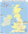
Ficheiro:Map of the administrative geography of the United Kingdom.png

Dimensões desta antevisão: 402 × 599 píxeis. Outras resoluções: 161 × 240 píxeis | 322 × 480 píxeis | 516 × 768 píxeis | 687 × 1 024 píxeis | 1 375 × 2 048 píxeis | 2 806 × 4 179 píxeis.
Imagem numa resolução maior (2 806 × 4 179 píxeis, tamanho: 1,06 MB, tipo MIME: image/png)
Histórico do ficheiro
Clique uma data e hora para ver o ficheiro tal como ele se encontrava nessa altura.
| Data e hora | Miniatura | Dimensões | Utilizador | Comentário | |
|---|---|---|---|---|---|
| atual | 15h32min de 1 de abril de 2023 |  | 2 806 × 4 179 (1,06 MB) | NordNordWest | upd April 2023 |
| 21h34min de 15 de novembro de 2022 |  | 2 806 × 4 179 (1,07 MB) | NordNordWest | update Buckinghamshire and Northamptonshire | |
| 18h38min de 7 de maio de 2019 |  | 2 806 × 4 179 (1,77 MB) | Chumwa | Aktualisierung: Änderungen in der Verwaltungsgliederung am 1.4.2019 | |
| 18h10min de 3 de março de 2019 |  | 2 806 × 4 179 (1,78 MB) | Chumwa | falsche Anzahl an non-metropolitan ceremonial counties im Infokasten für England korrigiert | |
| 19h21min de 8 de outubro de 2015 |  | 2 806 × 4 179 (1,78 MB) | Chumwa | falsche Datei erwischt... | |
| 19h19min de 8 de outubro de 2015 |  | 3 703 × 4 450 (2,29 MB) | Chumwa | Aktualisierung: Am 1. April ist eine Verwaltungsreform in Nordirland in Kraft getreten. | |
| 17h43min de 15 de abril de 2013 |  | 2 806 × 4 179 (1,82 MB) | Chumwa | Isle of Wight | |
| 21h50min de 14 de setembro de 2011 |  | 2 806 × 4 179 (1,68 MB) | Chumwa | corr | |
| 05h38min de 27 de maio de 2010 |  | 2 806 × 4 179 (1,66 MB) | Chumwa | civil parishes were replaced by communities in Wales in 1974 | |
| 21h42min de 25 de maio de 2010 |  | 2 806 × 4 179 (1,66 MB) | Chumwa | ein paar Verbesserungen... |
Utilização local do ficheiro
As seguintes 2 páginas usam este ficheiro:
Utilização global do ficheiro
As seguintes wikis usam este ficheiro:
- ar.wikipedia.org
- az.wikipedia.org
- be.wikipedia.org
- bg.wikipedia.org
- bs.wikipedia.org
- de.wikipedia.org
- en.wikipedia.org
- Talk:Bromley and Chislehurst (UK Parliament constituency)
- Talk:Lewisham Deptford (UK Parliament constituency)
- Administrative geography of the United Kingdom
- Talk:University constituency
- Talk:Rotten and pocket boroughs
- Talk:Foyle (UK Parliament constituency)
- Talk:Fermanagh and South Tyrone (UK Parliament constituency)
- Talk:Belfast South (UK Parliament constituency)
- Talk:Belfast North (UK Parliament constituency)
- Talk:Combined Scottish Universities (UK Parliament constituency)
- Talk:Tralee (UK Parliament constituency)
- Talk:Belfast West (UK Parliament constituency)
- Category talk:Constituencies of the Parliament of the United Kingdom
- Talk:List of United Kingdom Parliament constituencies (2005–2010)
- Talk:Aberavon (UK Parliament constituency)
- Talk:Hampstead and Highgate (UK Parliament constituency)
- Talk:Folkestone and Hythe (UK Parliament constituency)
- Template:WikiProject UK Parliament constituencies
- Category talk:Constituencies of the Parliament of the United Kingdom (historic)
- Talk:Armagh (UK Parliament constituency)
- Talk:Caithness and Sutherland (UK Parliament constituency)
- Talk:East Gloucestershire (UK Parliament constituency)
- Talk:Londonderry (UK Parliament constituency)
- Talk:Queen's University of Belfast (UK Parliament constituency)
- Talk:Roscommon (constituency)
- Talk:Beckenham (UK Parliament constituency)
- Talk:Bosworth (UK Parliament constituency)
- Talk:Blaydon (UK Parliament constituency)
- Talk:Braintree (UK Parliament constituency)
- Talk:Bethnal Green and Bow (UK Parliament constituency)
- Talk:Bridgwater (UK Parliament constituency)
- Talk:Brent East (UK Parliament constituency)
- Talk:Bromsgrove (UK Parliament constituency)
- Talk:Caithness, Sutherland and Easter Ross (UK Parliament constituency)
- Talk:Calder Valley (UK Parliament constituency)
- Talk:North West Cambridgeshire (UK Parliament constituency)
- Talk:Canterbury (UK Parliament constituency)
Ver mais utilizações globais deste ficheiro.
Metadados
🔥 Top keywords: Wikipédia:Página principalEspecial:PesquisarChatGPTJacqueline LaurenceEduardo Pereira RodriguesCleópatraCampeonato Europeu de FutebolLuciano da Rocha NevesFicheiro:Logotipo da GloboNews.pngEdson FieschiHouse of the DragonKylian MbappéCampeonato Europeu de Futebol de 2024Jogos Olímpicos de Verão de 2024Sony ChannelYouTubeAntoine GriezmannMaya MassaferaCanal BrasilBridgertonCampeonato Europeu de Futebol de 2020BrasilAMBEVMichel LaurenceCristiano RonaldoCopa AméricaEslováquia17 de junhoCopa do Mundo FIFAFalamansaCopa América de 2024EscadinhaChéquiaJuan Paiva24 Horas de Le MansSegunda Guerra MundialChico BuarqueEd SheeranJogo do bicho


