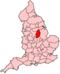
Broxtowe
Broxtowe is een Engels district in het shire-graafschap (non-metropolitan county OF county) Nottinghamshire en telt 107.570 inwoners. De oppervlakte bedraagt 80 km².
| Niet-metropolitaans district in Engeland | |||
|---|---|---|---|
  | |||
| Situering | |||
| Land | Engeland | ||
| County | Nottinghamshire | ||
| Regio | East Midlands | ||
| Coördinaten | |||
| Algemeen | |||
| Oppervlakte | 80,0989[1] km² | ||
| Inwoners (2001) | 107.570 (1343 inw./km²) | ||
| ONS-code | E07000172 | ||
| Website | Officiële website | ||
| Detailkaart | |||
 | |||
| |||
Van de bevolking is 16,4% ouder dan 65 jaar. De werkloosheid bedraagt 2,6% van de beroepsbevolking (cijfers volkstelling 2001).
Civil parishes in district Broxtowe
Awsworth, Brinsley, Cossall, Eastwood, Greasley, Kimberley, Nuthall, Stapleford, Strelley, Trowell.
Bronnen, noten en/of referenties
🔥 Top keywords: HoofdpaginaShannen DohertyLamine YamalEuropees kampioenschap voetbal mannenNico WilliamsSpeciaal:ZoekenCarlos Alcaraz (tennisser)AR-15Dani OlmoDonald TrumpEngels voetbalelftal (mannen)Spaans voetbalelftal (mannen)Tadej PogačarOlympiastadion (Berlijn)Wereldkampioenschap voetbal 2026Novak DjokovicPhil FodenEuropees kampioenschap voetbal 2024Álvaro MorataRobin Le NormandWereldkampioenschap voetbalLuke PerryLijst van winnaars van de Ronde van FrankrijkAndrés IniestaIñaki WilliamsMarc CucurellaHarry KaneEuropees kampioenschap voetbal 2020Europees kampioenschap voetbal 2028Rafael van der VaartDaniel CarvajalMaurits LammertinkKyle WalkerLuis de la FuenteCole PalmerMikel OyarzabalFrançois LetexierHet kleine huis op de prairie (televisieserie)Felipe VI van Spanje