

Oorspronkelijk bestand (SVG-bestand, nominaal 1.150 × 1.050 pixels, bestandsgrootte: 61 kB)
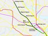
| BeschrijvingMBTA Green Line.svg | English: Schematic map of MBTA Green Line branches and stops, including abandoned Watertown (A) and Extension (under construction). Station names sourced from Wikipedia articles and 2014 Blue Book. |
| Datum | |
| Bron | Eigen werk |
| Auteur | Mliu92 |
| Andere versies | Dit bestand is afgeleid van: |
Klik op een datum/tijd om het bestand te zien zoals het destijds was.
| Datum/tijd | Miniatuur | Afmetingen | Gebruiker | Opmerking | |
|---|---|---|---|---|---|
| huidige versie | 12 dec 2022 20:02 | | 1.150 × 1.050 (61 kB) | Pi.1415926535 | update for GLX opening |
| 19 mrt 2022 19:57 |  | 1.150 × 1.050 (32 kB) | Mliu92 | Updates to E branch & opening of Union Square branch past Lechmere. | |
| 27 sep 2021 18:44 |  | 1.150 × 1.050 (42 kB) | Mliu92 | Updated name: College Ave -> Medford/Tufts | |
| 2 jan 2019 19:45 |  | 1.150 × 1.050 (42 kB) | Mliu92 | Switched lables for St Paul St / Babcock St. | |
| 28 dec 2018 17:58 |  | 1.150 × 1.050 (42 kB) | Mliu92 | Removed hidden layer, improved text display (buggy overuse of bold). | |
| 28 dec 2018 17:50 |  | 1.150 × 1.050 (218 kB) | Mliu92 | User created page with UploadWizard |
Dit bestand wordt op de volgende pagina gebruikt:
De volgende andere wiki's gebruiken dit bestand:
Dit bestand bevat metadata met EXIF-informatie, die door een fotocamera, scanner of fotobewerkingsprogramma toegevoegd kan zijn.
| Breedte | 1150 |
|---|---|
| Hoogte | 1050 |


