Vaizdas:Rzeczpospolita Lithuania claims.png
Nėra didesnės raiškos varianto.
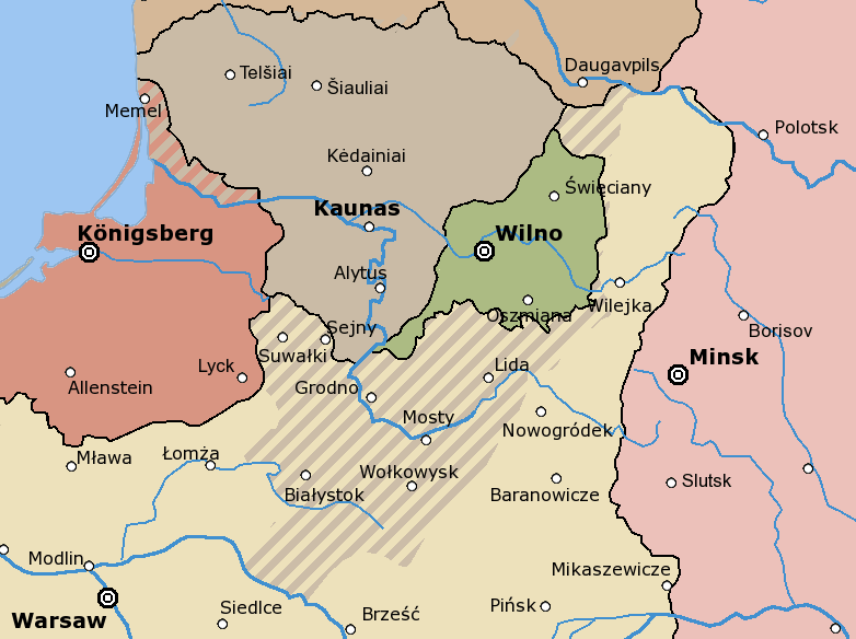
Rzeczpospolita_Lithuania_claims.png (782 × 584 taškų, rinkmenos dydis: 29 KiB, MIME tipas: image/png)
| Ši byla yra iš bendros Wikimedia Commons nemokamų resursų duomenų bazės, palaikomos Wikimedia Foundation organizacijos. Norėdami sužinoti licencijavimo smulkmenas, žiūrėkite paveikslėlio aprašymą |  | Į paveikslėlio aprašymą |
Map showing the extent of Lithuanian (gray) claims on neighbouring countries in the interbellum (Germany - red, Poland - yellow), as well as the short-lived Republic of Central Lithuania (marked in green), also claimed by Lithuania, but eventually joined with Poland in 1922
The following is a list of maps created by Halibutt and uploaded to commons, as well as their present and projected derivatives.
| Parent Image | Image | Description | |||||||||||
|---|---|---|---|---|---|---|---|---|---|---|---|---|---|
| Maps by Halibutt | |||||||||||||
| Image:Rzeczpospolita.png | Image:Rzeczpospolita.png | The Republic in 17th and 18th century | |||||||||||
| Image:Rzeczpospolita 1600.png | The Republic after the Treaty of Dywilino | ||||||||||||
| Image:Rzeczpospolita voivodships.png | Voivodships of The Republic | ||||||||||||
| Image:Rzeczpospolita_Potop.png | The Republic during The Deluge and Chmielnicki Uprising, with major battles of the era marked | ||||||||||||
| Magnates and their lands and domains | |||||||||||||
| 1st • 2nd • 3rd | Partitions of Poland | ||||||||||||
| War of the constitution | |||||||||||||
| Image:Rzeczpospolita.xcf | SOURCE FILE - GIMP format | ||||||||||||
| Image:Poland 1939.png | Image:Poland 1939.png | Poland in 1939 | |||||||||||
| Image:Dywizje wrzesien 1.png | Order of Battle on September 1st, during the Polish Defence War of 1939 | ||||||||||||
| Image:Poland 1939.xcf | SOURCE FILE - GIMP format | ||||||||||||
| Image:Polska kontur bialy.png | Image:Polska kontur bialy.png | Contour map of Poland AD 1999, for use with various locator maps | |||||||||||
| Image:Rzeczpospolita 1923.png | Image:Rzeczpospolita 1923.png | Map of Poland 1918-1939, currently under development | |||||||||||
| Image:PBW March 1919.png | Polish-Bolshevik War - fronts in March of 1919 | ||||||||||||
| Image:PBW December 1919.png | Polish-Bolshevik War - fronts in December of 1919 | ||||||||||||
| Image:PBW June 1920.png | Polish-Bolshevik War - fronts in July of 1920 | ||||||||||||
| Image:PBW August 1920.png | Polish-Bolshevik War - fronts in August of 1920 | ||||||||||||
| Polish Defence War of 1939 | |||||||||||||
| Polish areas annexed by Germany, Lithuania, Slovakia and the Soviet Union | |||||||||||||
| German concentration camps in Poland | |||||||||||||
| Curzon line | |||||||||||||
| Major battles of the Polish-Bolshevik War | |||||||||||||
| names • no names | Polish/Czechoslovak/Lithuanian/German/Ukrainian claims in 1920's | ||||||||||||
| Image:Rzeczpospolita Central Lithuania.png | Central Lithuania | ||||||||||||
| Image:Rzeczpospolita Lithuania claims.png | Central Lithuania as compared with other Lithuanian claims | ||||||||||||
| Image:Rzeczpospolita 1789-1920.png | Post-1922 borders compared with the territory of Poland before the partitions | ||||||||||||
| Warsaw Uprising and the Operation Tempest | |||||||||||||
| Poland partitioned between the Soviets and the Germans | |||||||||||||
| Image:Rzeczpospolita 1939 Polish divisions.png | Polish divisions on September 1, 1939 | ||||||||||||
| Home Army inspectorates | |||||||||||||
| Image:Rzeczpospolita 1922.xcf | SOURCE FILE - GIMP format | ||||||||||||
| Image:Rzeczpospolita 1937.svg | Vector version!!!! | layered version available on request | |||||||||||
Since the legal status of the above comment has been questioned, I hereby grant anyone the right to treat it as either a standard copyright notice, invariant section, legal statement, legal advice, friendly suggestion or a mere comment, depending on his or hers own choice. |
|

Rinkmenos istorija
Paspauskite ant datos/laiko, kad pamatytumėte rinkmeną tokią, kokia ji buvo tuo metu.
| Data/Laikas | Miniatiūra | Matmenys | Naudotojas | Paaiškinimas | |
|---|---|---|---|---|---|
| dabartinis | 09:13, 25 gegužės 2005 | | 782 × 584 (29 KiB) | Halibutt | Map showing the extent of Lithuanian claims on neighbouring countries in the interbellum, as well as the short-lived Republic of Central Lithuania (marked in green), also claimed by Lithuania, but eventually joined with Poland in 1922<br>{{User:Halibutt/m |
Paveikslėlio naudojimas
Paveikslėlis yra naudojamas šiuose puslapiuose:
Visuotinis rinkmenos naudojimas
Ši rinkmena naudojama šiose viki svetainėse:
- Naudojama be-tarask.wikipedia.org
- Naudojama be.wikipedia.org
- Naudojama bn.wikipedia.org
- Naudojama ca.wikipedia.org
- Naudojama cs.wikipedia.org
- Naudojama de.wikipedia.org
- Naudojama el.wikipedia.org
- Naudojama en.wikipedia.org
- Naudojama fi.wikipedia.org
- Naudojama fr.wikipedia.org
- Naudojama hu.wikipedia.org
- Naudojama it.wikipedia.org
- Naudojama lv.wikipedia.org
- Naudojama nl.wikipedia.org
- Naudojama no.wikipedia.org
- Naudojama pl.wikipedia.org
- Naudojama ro.wikipedia.org
- Naudojama ru.wikipedia.org
- Naudojama tr.wikipedia.org
- Naudojama uk.wikipedia.org
Žiūrėti visuotinį šios rinkmenos naudojimą.
🔥 Top keywords: Pagrindinis puslapisUEFA Europos futbolo čempionatasFIFA pasaulio čempionatasDonald TrumpSpecialus:PaieškaBerlyno Olimpinis stadionasViesulasIspanijos vyrų futbolo rinktinėZodiakasAnglijos vyrų futbolo rinktinėXVII Europos futbolo čempionatas2024 m. vasaros olimpinės žaidynėsSpecialus:Naujausi keitimaiLietuvaFutbolas2024 m. JAV prezidento rinkimaiElžbieta VitelsbachFutbolo aikštėVilniusIspanijos himnasXVI Europos futbolo čempionatasSąrašas:JAV prezidentaiBastilijos paėmimo dienaSąrašas:Lietuvos miestai pagal gyventojusRose NamajunasJoe BidenLietuvos nacionalinis radijas ir televizijaAnglijaIspanijaJohn F. KennedyVaizdas:Kalvaičių dvaro rūmai.jpgSąrašas:Šalių telefonų kodai pagal šalies pavadinimąŽilakrūmisIspanijos karaliusSąrašas:Europos Sąjungos valstybės narėsNuošalėDariaus ir Girėno stadionasJungtinė KaralystėÁlvaro Morata