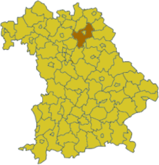
Bayreuth (circundari)
Chest artícol a l'è scricc in Lumbàrt, ortograféa orientàl unificàda. |
El Circondàre de Bayreuth l'è giü dei 71 circondàre de la Baviera. El se tróa 'ndèla Alta Francònia, endèla Germània del sud.
| Bayreuth | |||
|---|---|---|---|
| |||
| Informasiù statìstiche | |||
| Land | Baviera | ||
| Capital | Bayreuth | ||
| Distret | Alta Francònia | ||
| Superfice | 1273,1 km² | ||
| Popolasiù | 108.312 ab. (30/09/2006) | ||
| Densità | 85 ab/km² | ||
| Sigla (autom.) | BT | ||
| Sit uficiàl | www.landkreis-bayreuth.de | ||
| Aministrasiù del distrèt | |||
| Indirìs | Markgrafenallee 5 95448 Bayreuth | ||
| Aministradùr | Hermann Hübner | ||
| Partit | CSU | ||
| Ubicasiù 'ndèl sò Land | |||
 | |||
Cità e cümü

(Nömer de abitàncc agiurnàt al 31. Dezèmber 2016[1])
Cità
| Cümü
|
 | Schloss Aufseß | Aufseß |
 | Schloss Freienfels | Hollfeld |
 | Hollfeld | Hollfeld |
 | Pegnitz | Pegnitz |
 | Burg Pottenstein | Pottenstein |
 | Teufelshöhle | Pottenstein |
 | Tüchersfeld | Pottenstein |
 | Burg Waischenfeld | Waischenfeld |
 | Schloss Wiesentfels | Hollfeld |
Riferimèncc
🔥 Top keywords: Pagina principalaCarles Puigdemont i CasamajóDario GreggioSalvatore CinquegranaSegónda guèra mondiàlCategoria:BotànicajcqiqSpecial:RiçercaMonica RoccaforteAllie HazeZeb89Special:CambiamentRecentWikipediaLingua piccardaValudaAlessandro OrsiniWikipedia:GrottStefano Lepri (youtuber)LombardLengua lombardaCarlo CodegaWikipedia:JüttWikipedia:Portal de la comunitàIrlandaFrancesca PresentiniSpecial:Mæ DiscûscioînCOVID-19Kelly MadisonGuerra de GazaGrande NordWeingarten (Karlsruhe)Bèpi & The PrismasAlbert EinsteinForze de Defesa de IsraellAndrea Di PieroWikipedia:Aveniment recentEnock BarwuahAlberto ZangrilloLa bella la va al fosso

