파일:Map of Montana highlighting Lewis and Clark County.svg

SVG 파일의 PNG 형식의 미리보기 크기: 800 × 461 픽셀. 다른 해상도: 320 × 185 픽셀 | 640 × 369 픽셀 | 1,024 × 590 픽셀 | 1,280 × 738 픽셀 | 2,560 × 1,476 픽셀 | 2,043 × 1,178 픽셀
원본 파일 (SVG 파일, 실제 크기 2,043 × 1,178 픽셀, 파일 크기: 100 KB)
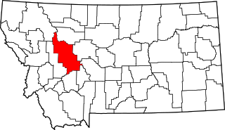
This is a locator map showing Lewis and Clark County in Montana.
| 나는 이 작품의 저작권자로서, 이 작품을 퍼블릭 도메인으로 모두에게 공개합니다. 이 공개 선언은 전 세계적으로 유효합니다. 만약 저작권의 포기가 법률적으로 가능하지 않은 경우, 나는 이 작품을 법적으로 허용되는 한도 내에서 누구나 자유롭게 어떤 목적으로도 제한없이 사용할 수 있도록 허용합니다. |
파일 역사
날짜/시간 링크를 클릭하면 해당 시간의 파일을 볼 수 있습니다.
| 날짜/시간 | 섬네일 | 크기 | 사용자 | 설명 | |
|---|---|---|---|---|---|
| 현재 | 2024년 6월 25일 (화) 09:20 | | 2,043 × 1,178 (100 KB) | Nux | fix rendering (remove clipping) |
| 2006년 2월 12일 (일) 22:30 |  | 9,194 × 5,303 (122 KB) | David Benbennick | {{subst:User:Dbenbenn/clm|county=Lewis and Clark County|state=Montana|type=county}} |
이 파일을 사용하는 문서
다음 문서 2개가 이 파일을 사용하고 있습니다:
이 파일을 사용하고 있는 모든 위키의 문서 목록
다음 위키에서 이 파일을 사용하고 있습니다:
- ar.wikipedia.org에서 이 파일을 사용하고 있는 문서 목록
- bg.wikipedia.org에서 이 파일을 사용하고 있는 문서 목록
- bpy.wikipedia.org에서 이 파일을 사용하고 있는 문서 목록
- cdo.wikipedia.org에서 이 파일을 사용하고 있는 문서 목록
- ceb.wikipedia.org에서 이 파일을 사용하고 있는 문서 목록
- cy.wikipedia.org에서 이 파일을 사용하고 있는 문서 목록
- de.wikipedia.org에서 이 파일을 사용하고 있는 문서 목록
- en.wikipedia.org에서 이 파일을 사용하고 있는 문서 목록
- Helena, Montana
- List of counties in Montana
- Lewis and Clark County, Montana
- Augusta, Montana
- East Helena, Montana
- Helena Valley Northeast, Montana
- Helena Valley Northwest, Montana
- Helena Valley Southeast, Montana
- Helena Valley West Central, Montana
- Lincoln, Montana
- Helena West Side, Montana
- Marysville, Montana
- MacDonald Pass
- Rogers Pass (Montana)
- User:Nyttend/County templates/MT
- Template:Lewis and Clark County, Montana
- National Register of Historic Places listings in Lewis and Clark County, Montana
- Wolf Creek, Montana
- Craig, Montana
- List of lakes of Lewis and Clark County, Montana
- List of mountains in Lewis and Clark County, Montana
- Category:Populated places in Lewis and Clark County, Montana
- List of trails of Lewis and Clark County, Montana
- Rimini, Montana
- Unionville, Montana
- Canyon Creek, Montana
- Cadotte Pass
- Mike Horse, Montana
- Milford Colony, Montana
- Gilman, Montana
- York, Montana
이 파일의 더 많은 사용 내역을 봅니다.