

原始文件 (1,001 × 900像素,文件大小:182 KB,MIME类型:image/png)
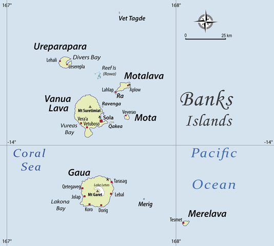
| 描述Womtelo Map-Banks-Vanuatu 1000.png | English: I have drawn this map of the Banks Islands (Vanuatu) based on several other maps showing sufficient precision. I paid special attention to the transcription of place names, based on personal fieldwork in the Banks Islands, and professional knowledge of the various local languages. |
| 日期 | |
| 来源 | 自己的作品 |
| 作者 | Alexandre François |
| 授权 (二次使用本文件) | 本文件采用知识共享署名 3.0 未本地化版本许可协议授权。 署名: Alexandre François
|
 | 已授权您依据自由软件基金会发行的无固定段落及封面封底文字(Invariant Sections, Front-Cover Texts, and Back-Cover Texts)的GNU自由文件许可协议1.2版或任意后续版本的条款,复制、传播和/或修改本文件。该协议的副本请见“GNU Free Documentation License”。http://www.gnu.org/copyleft/fdl.htmlGFDLGNU Free Documentation Licensetruetrue |
点击某个日期/时间查看对应时刻的文件。
| 日期/时间 | 缩略图 | 大小 | 用户 | 备注 | |
|---|---|---|---|---|---|
| 当前 | 2010年11月23日 (二) 05:46 | | 1,001 × 900(182 KB) | Womtelo | {{Information |Description={{en|1=I have drawn this map of the Banks Islands (Vanuatu) based on several other maps showing sufficient precision. I paid special attention to the transcription of place names, based on personal fieldwork in the Banks Islands |
以下其他wiki使用此文件:
查看此文件的更多全域用途。