

Originalfil (SVG-fil, standardstorlek: 778 × 885 pixlar, filstorlek: 121 kbyte)
| Denna fil tillhandahålls av Wikimedia Commons. Informationen nedan är kopierad från dess filbeskrivningssida. |
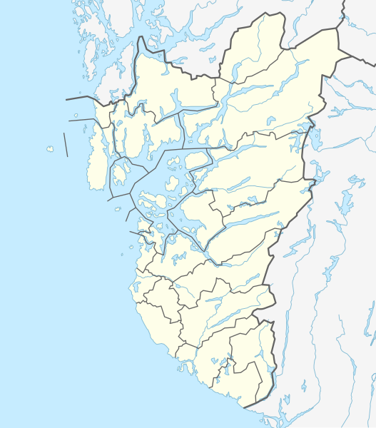
| BeskrivningNorway Rogaland adm location map.svg |
| ||||||||||||
| Datum | |||||||||||||
| Källa | Eget arbete med hjälp av: United States National Imagery and Mapping Agency data | ||||||||||||
| Skapare | NordNordWest | ||||||||||||
| Andra versioner | |||||||||||||
 | This map has been made or improved in the German Kartenwerkstatt (Map Lab). You can propose maps to improve as well. azərbaycanca ∙ čeština ∙ Deutsch ∙ Deutsch (Sie-Form) ∙ English ∙ español ∙ français ∙ italiano ∙ latviešu ∙ magyar ∙ Nederlands ∙ Plattdüütsch ∙ polski ∙ português ∙ română ∙ sicilianu ∙ slovenščina ∙ suomi ∙ македонски ∙ русский ∙ ქართული ∙ հայերեն ∙ বাংলা ∙ ไทย ∙ +/− |
Usage of this file with:

explanatory notes: Legally binding is only the full legalcode. For a free usage I recommend to respect the following licence conditions:
1. Provide my name as given above: NordNordWest,
2. a copy of, or the URI for, the applicable license: https://creativecommons.org/licenses/by-sa/3.0/de/legalcode,
3. the title of the work,
4. in the case of an adaptation, a credit identifying the use of the work in the adaptation.
This license and the rights granted hereunder will terminate automatically upon any breach by you of the terms of this license. Any of the above conditions can be waived if you get permission from the copyright holder. If you have questions or wish differing conditions, please contact me through nnwest or my discussion page ![]() t-online.de
t-online.de

Klicka på ett datum/klockslag för att se filen som den såg ut då.
| Datum/Tid | Miniatyrbild | Dimensioner | Användare | Kommentar | |
|---|---|---|---|---|---|
| nuvarande | 10 juni 2020 kl. 04.45 | | 778 × 885 (121 kbyte) | Jay1279 | fix Strand-Sandnes border after 2020 boundary change |
| 18 januari 2020 kl. 21.12 |  | 778 × 885 (114 kbyte) | NordNordWest | corr | |
| 2 januari 2020 kl. 15.51 |  | 778 × 885 (114 kbyte) | NordNordWest | == {{int:filedesc}} == {{Information |description= {{de|1=Positionskarte von {{Wd|Rogaland}}, {{Wd|Norwegen}}}} {{en|1=Location map of {{W|Rogaland}}, {{W|Norway}}}} {{Location map series N |stretching=194 |top=59.9 |bottom=58.2 |left=4.5 |right=7.4 }} |source={{Own using}} United States National Imagery and Mapping Agency data |date=2020-01-02 |author={{U|NordNordWest}} |permission= |other_versions= }} {{Kartenwerkstatt}} == {{int:license-header}} == {{User:NordNordWest/LicenceMap}} [[Cate... |
Följande 71 sidor använder den här filen:
Följande andra wikier använder denna fil:
Visa mer globalt användande av denna fil.
Den här filen innehåller extrainformation som troligen lades till av en digitalkamera eller skanner när filen skapades. Om filen har modifierats kan det hända att vissa detaljer inte överensstämmer med den modifierade filen.
| Bredd | 778.198px |
|---|---|
| Höjd | 885.104px |
