From Wikipedia, the free encyclopedia
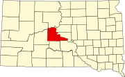
 Location of Stanley County in South Dakota
This is a list of the National Register of Historic Places listings in Stanley County, South Dakota.
This is intended to be a complete list of the properties on the National Register of Historic Places in Stanley County, South Dakota, United States. The locations of National Register properties for which the latitude and longitude coordinates are included below, may be seen in a map.[1]
There are 12 properties listed on the National Register in the county, including 2 National Historic Landmarks.
This National Park Service list is complete through NPS recent listings posted July 5, 2024.[2]
Current listings
| [3] | Name on the Register[4] | Image | Date listed[5] | Location | City or town | Description |
|---|
| 1 | American Legion Community Hall | Upload image | July 31, 2017
(#100001403) | 115 Deadwood St.
44°21′17″N 100°22′17″W / 44.35483°N 100.371449°W / 44.35483; -100.371449 (American Legion Community Hall) | Fort Pierre | |
|---|
| 2 | Antelope Creek Site (39ST55) | Upload image | August 14, 1986
(#86002737) | Address Restricted
| Fort Pierre | |
|---|
| 3 | Bloody Hand Site (39ST230) | Upload image | August 14, 1986
(#86002736) | Address Restricted
| Fort Pierre | |
|---|
| 4 | Breeden Village | Upload image | June 2, 2003
(#03000503) | Address Restricted
| Fort Pierre | |
|---|
| 5 | Jefferson Davis Carr House | 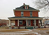 Jefferson Davis Carr House Jefferson Davis Carr House | March 5, 1982
(#82003942) | 236 W. 2nd Ave.
44°21′17″N 100°22′33″W / 44.354722°N 100.375833°W / 44.354722; -100.375833 (Jefferson Davis Carr House) | Fort Pierre | |
|---|
| 6 | Fort Pierre Chouteau Site | 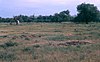 Fort Pierre Chouteau Site Fort Pierre Chouteau Site | April 3, 1976
(#76001756) | North of Fort Pierre
44°23′27″N 100°22′58″W / 44.390833°N 100.382778°W / 44.390833; -100.382778 (Fort Pierre Chouteau Site) | Fort Pierre | |
|---|
| 7 | Fort Pierre II (39ST217) | Upload image | August 15, 1988
(#88000732) | Address Restricted
| Fort Pierre | |
|---|
| 8 | La Verendrye Site | 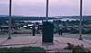 La Verendrye Site La Verendrye Site | August 7, 1974
(#74001899) | Off U.S. Route 83
44°21′19″N 100°22′40″W / 44.355278°N 100.377778°W / 44.355278; -100.377778 (La Verendrye Site) | Fort Pierre | |
|---|
| 9 | Lower Antelope Creek Site | Upload image | September 15, 1982
(#82003943) | Address Restricted
| Fort Pierre | |
|---|
| 10 | Old Fort Pierre School | 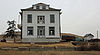 Old Fort Pierre School Old Fort Pierre School | November 25, 1977
(#77001255) | 2nd Ave. and 2nd St.
44°21′17″N 100°22′31″W / 44.354722°N 100.375278°W / 44.354722; -100.375278 (Old Fort Pierre School) | Fort Pierre | |
|---|
| 11 | Stockgrowers Bank Building | 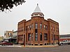 Stockgrowers Bank Building Stockgrowers Bank Building | November 11, 1977
(#77001256) | Deadwood and Main Sts.
44°21′16″N 100°22′10″W / 44.354444°N 100.369444°W / 44.354444; -100.369444 (Stockgrowers Bank Building) | Fort Pierre | |
|---|
| 12 | Gaylord Sumner House | 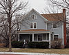 Gaylord Sumner House Gaylord Sumner House | December 21, 1977
(#77001257) | 2nd and Wandel Sts.
44°20′52″N 100°22′15″W / 44.347778°N 100.370833°W / 44.347778; -100.370833 (Gaylord Sumner House) | Fort Pierre | |
|---|
| 13 | United Church of Christ, Congregational |  United Church of Christ, Congregational United Church of Christ, Congregational | December 21, 1977
(#77001258) | 2nd and Main St.
44°21′13″N 100°22′29″W / 44.353611°N 100.374722°W / 44.353611; -100.374722 (United Church of Christ, Congregational) | Fort Pierre | |
|---|
See also
References
|
|---|
| Topics | | |
|---|
Lists by
county | |
|---|
| Other lists | |
|---|
|