

Original file (776 × 745 pixels, file size: 993 KB, MIME type: image/png)
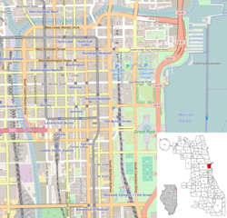
| DescriptionLoop Chicago.PNG | This map was created from OpenStreetMap project data, collected by the community. This map may be incomplete, and may contain errors. Don't rely solely on it for navigation. | |||||||||
| Date | (see file history) | |||||||||
| Source | openstreetmap.org | |||||||||
| Creator | OpenStreetMap contributors | |||||||||
| Permission (Reusing this file) | OpenStreetMap data and maps are licensed under the Creative Commons Attribution-ShareAlike 2.0 license (CC-BY-SA 2.0). This file is licensed under the Creative Commons Attribution-Share Alike 2.0 Generic license.
| |||||||||
| Geotemporal data | ||||||||||
| Bounding box |
| |||||||||
| Georeferencing | Georeference the map in Wikimaps Warper If inappropriate please set warp_status = skip to hide. | |||||||||
Click on a date/time to view the file as it appeared at that time.
| Date/Time | Thumbnail | Dimensions | User | Comment | |
|---|---|---|---|---|---|
| current | 14:38, 27 March 2017 | | 776 × 745 (993 KB) | Mindfrieze | Adjusted map area to fit entire extents of Loop Community Area; Removed unnecessary image stretch along horizontal axis. |
| 15:34, 15 May 2010 |  | 960 × 720 (744 KB) | Dr. Blofeld~commonswiki |
The following other wikis use this file:
This file contains additional information, probably added from the digital camera or scanner used to create or digitize it.
If the file has been modified from its original state, some details may not fully reflect the modified file.
| Horizontal resolution | 28.35 dpc |
|---|---|
| Vertical resolution | 28.35 dpc |
| File change date and time | 14:35, 27 March 2017 |