استان ماسوویان
ماسوویان وویوودشیپ (به لاتین: Masovian Voivodeship) یکی از استانهای لهستان است.[۱]
Masovian Voivodeship Województwo mazowieckie | |
|---|---|
 Location within Poland | |
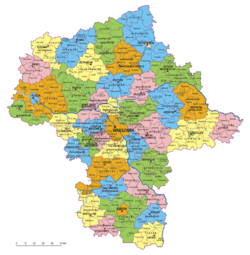
 Division into counties | |
| مختصات (Warsaw): ۵۲°۱۳′ شمالی ۲۱°۰′ شرقی / ۵۲٫۲۱۷°شمالی ۲۱٫۰۰۰°شرقی | |
| کشور | |
| پایتخت | ورشو |
| Counties | 5 cities, 37 land counties *
|
| مساحت | |
| • Total | ۳۵۵۷۹ کیلومتر مربع (۱۳۷۳۷ مایل مربع) |
| جمعیت (۲۰۰۶) | |
| • Total | ۵۱۶۴۶۱۲ |
| • تراکم | ۱۵۰/کیلومتر مربع (۳۸۰/مایل مربع) |
| • شهری | ۳۳۴۳۲۳۱ |
| • Rural | ۱۸۲۱۳۸۱ |
| Car plates | W |
| وبگاه | |
| |
خصوصیات
ماسوویان وویوودشیپ ۳۵٬۵۷۹ کیلومترمربع مساحت و ۵٬۱۶۴٬۶۱۲ نفر جمعیت دارد.
جستارهای وابسته
منابع
🔥 Top keywords: مصطفی پورمحمدیمسعود پزشکیانعلیرضا زاکانیصفحهٔ اصلیسید امیرحسین قاضیزاده هاشمیسعید جلیلیمحمدباقر قالیبافناصر مکارم شیرازیویژه:جستجوتب دنگیانتخابات ریاستجمهوری ایران (۱۴۰۰)انتخابات ریاستجمهوری ایران (۱۴۰۳)دادگاه حمید نوریرده:پوزیشنهای جنسیعید قربانسید حسن قاضیزاده هاشمینامزدهای انتخابات ریاستجمهوری ایران (۱۴۰۳)سید احسان قاضیزاده هاشمیشیدا خلیقجام ملتهای اروپا ۲۰۲۴سید ابراهیم رئیسیرده:فیلمهای سکسی-کمدی آمریکاییروشهای آمیزش جنسیسید علی خامنهایلحظه گرگ و میشآمیزش جنسی بدون دخولدر انتهای شب (مجموعه نمایش خانگی ۱۴۰۳)سید حسین قاضیزاده هاشمیمریم رجویمحمود احمدینژادنفیلیمعلیاصغر پورمحمدیسکس شاپحسین انتظامیآمیزش جنسی دهانییان فن ت شیپانتخابات ریاستجمهوری ایران (۱۳۹۶)جام ملتهای اروپاناهید مسلمی

