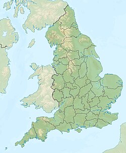
Cheshire
Cheshire estas unu el la graflandoj de Anglio. Ĝi situas en la regiono nordokcidenta Anglio. La ĉefurbo estas Chester (Ĉestro).
- Loĝantaro - 979 000 (en 2000).
- Areo - 2 328 km²

| Cheshire | |||
|---|---|---|---|
| Graflando | |||
 | |||
 |  | ||
| Flago | Blazono | ||
| ceremonia kantono de Anglio [+] | |||
| Lando | Anglio | ||
| Koordinatoj | , 3° U (mapo)53.166666666667-2.583333333333353° N, 3° U (mapo) | ||
| Ĉefurbo | Chester | ||
| - koordinatoj | , 3° U (mapo)53.166666666667-2.583333333333353° N, 3° U (mapo) [+] | ||
| Akvokolektejo | 2 342,77 km² (234 277 ha) [+] | ||
| Areo | 2 342,77 km² (234 277 ha) [+] | ||
| Loĝantaro | 1 069 646 [+] (2020) | ||
| ISO 3166-2 | GB-CHW | ||
| |||
 | |||
| Cheshire | |||
Industrio - agrikulturo, aŭtomobiloj, petrokemiaĵoj
Urboj kaj vilaĝoj
- Acton, Alderley Edge, Alsager, Aldford, Astbury, Audlem
- Barton, Beeston, Bickerton, Bollington, Bucklow Hill, Bunbury, Burton (Willaston), Burton (Taporley)
- Chester, Congleton, Crewe
- Disley
- Elworth
- Farndon, Frodsham
- Gawsworth, Great Budworth
- Kelsall, Kerridge, Knutsford
- Langley, Ledsham, Lower Peover
- Maklesfildo (Macclesfield), Malpas, Marston, Middlewich, Mobberley
- Nantwich, Neston, Northwich
- Parkgate, Peckforton, Poynton, Prestbury
- Sandbach, Siddington, Stretton, Styal, Swettenham
- Tarporley, Tarvin, Tattenhall, Timbersbrook
- Warburton, Warmingham, Weaverham, Willaston, Wilmslow, Winsford, Wybunbury
Vizitindaĵoj
- Adlington Hall
- Arley Hall
- Capesthorne Hall
- Dunham Hall
- Elton Hall
- Gawsworth Hall
- Holt Castle
- Lyme Hall, Lyme Park
- Little Moreton Hall
- Moss Hall
- Peover Hall
- Tabley House
- Tatton Hall, Tatton Park
- Beeston Castle
- Cholmondley Castle
- Peckforton Castle
- Sandbach Crosses
- Jodrell Bank
- Ellesmere Port Boat Museum
- Quarry Bank Mill, Styal
- Macclesfield Forest
- Ness Botanic Gardens
- Tegg's Nose Country Park
- Shropshire Union Canal
- Trent and Mersey Canal
- Anderton Boat Lift
🔥 Top keywords: Vikipedio:ĈefpaĝoSpecialaĵo:SerĉiCarles Puigdemont i CasamajóSpecialaĵo:Lastaj ŝanĝojAlgoritmo de LuhnEsperantoHarvey-saŭcoDua MondmilitoVikipedioHelpo:EnhavoUzanto:男神輿/provejoVikipedio:KontaktojKategorioVikipedio:MalgarantioPortalo:KomunumoVikipedio:DiskutejoUzanto:DominikFajliloFlava galioVikipedio:Forigendaj artikolojHiphopoVikipedio:AktualaĵojAmiotrofa lateralsklerozoSeksumadoMilena VelbaSerĉilo-optimumigoVikipedio:Bonvenon al VikipedioGiorgia MeloniBottropEjakuloPetr SepéšiDistrikto Borkenre4v1UsonoCharles Antoine Houdar de La MotteEmscher-KooperativoXXXTentacionValutoKrystyna Łuczak-Surówka


