
Bookmarks: HOME RANDOM TIPS  The Canadian Roadgeek/Gallery -- Wikipedia, The Free Encyclopedia -- Wikipedia Knowledge Explorer
 | |
| Wikipedia ads | file info – show another – #287 |
| Welcome to Edit Count: 7,166
| |
|---|---|
Wonder why Smcafirst went disappeared from Wikipedia from the end of April 2007 to the beginning of June 2007? I can suggest an answer: Smcafirst went on an expedition to Eastern Ontario and Southern Quebec to take pictures for Wikipedia! Isn't that exciting. Smcafirst took a total of about 130 images, and he will choose some of the most important (not necessarily the best, as some are poor in quality), and upload them bit-by-bit. Here is the gallery of his work.
Future expeditions
- York Region → Kingston → Ottawa - Gatineau → Saint Jerome → Montreal (Cancelled)
- York Region → Barrie → Gravenhurst → Bracebridge → Bancroft → Algonquin Provincial Park (May 2009)
- York Region → Kingston → Ottawa (Date unplanned)
- York Region → Toronto → Hamilton → London → Chatham-Kent → Pelee Island OR Leamington OR Tecumseh OR Windsor → Detroit (Date unplanned)
List of expeditions of Smcafirst
- York Region to Downtown Montreal (April 2007 to June 2007)
- York Region to Tobermory VIA Collingwood ; Owen Sound ; Wiarton ; Barrie ; Newmarket, and Orangeville (June 30, 2007 to July 2, 2007)
- York Region to St. Jacobs VIA Kitchener ; and Waterloo (Mid August)
- York Region to Niagara Falls VIA Oakville ; Hamilton ; and St. Catharines (August 17, 2007)
- York Region to Peterborough VIA Northern Durham Region; and City of Kawartha Lakes (Lindsay) (May 18, 2008)
- York Region → Toronto → Buffalo, New York → Albany, New York → New York City and area → Syracuse, New York → Thousand Islands (August 2 to August 5, 2008)
York Region → Durham Region → Trent-Severn Waterway → Kingston → Brockville → Cornwall → Montreal →Laval
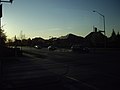 Carlton Road looking east from York Regional Road 3.
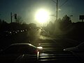 York Regional Road 7 looking east at the intersection of York Regional Road 3 at dawn.
 Oshawa, Ontario's skyline as seen from Whitby/Oshawa townline at Highway 401.
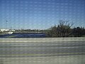
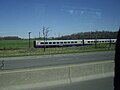 VIA Rail's train travelling at a high speed near Brockville, Ontario.
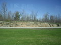 Canadian Shield landform.


York Region → Simcoe County → Dufferin County → Grey County → Bruce County → Tobermory


York Region → Kitchener → Waterloo → St. Jacobs
- More images coming soon.
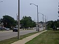 Waterloo Regional Road 15 (King Street) north of the half-clo intersection with Highway 8 looking south in Kitchener, Ontario.

York Region → Durham Region → Kawartha Lakes → Peterborough

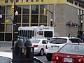 A bus of the Peterborough Transit on Water Street, Peterborough, Ontario.
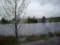 Otonabee River as it flows past Peterborough County Road 32 on a rainy day, near Lakefield, Ontario
 Kawartha Lakes Road 2, near Woodville and the intersection of Concession Road 1 of Thorah.


York Region → Toronto → Buffalo → Albany → New York City and area → Syracuse → Thousand Islands
- Highway 137's 1000-Islands International Bridge, northbound, near Ivy Lea, OntarioHighway 137's 1000-Islands International Bridge, northbound, near Ivy Lea, Ontario
 Interstate 90 looking east, near Syracuse, New York.
 Pearl Street in Albany, New York


🔥 Top keywords: Main PageSpecial:SearchPage 3Wikipedia:Featured picturesHouse of the DragonUEFA Euro 2024Bryson DeChambeauJuneteenthInside Out 2Eid al-AdhaCleopatraDeaths in 2024Merrily We Roll Along (musical)Jonathan GroffJude Bellingham.xxx77th Tony AwardsBridgertonGary PlauchéKylian MbappéDaniel RadcliffeUEFA European Championship2024 ICC Men's T20 World CupUnit 731The Boys (TV series)Rory McIlroyN'Golo KantéUEFA Euro 2020YouTubeRomelu LukakuOpinion polling for the 2024 United Kingdom general electionThe Boys season 4Romania national football teamNicola CoughlanStereophonic (play)Gene WilderErin DarkeAntoine GriezmannProject 2025