Tichit, or Tichitt (Berber languages: Ticit, Arabic: تيشيت), is a partly abandoned village at the foot of the Tagant Plateau in central southern Mauritania that is known for its vernacular architecture. The main agriculture in Tichit is date farming, and the village is also home to a small museum.
Tichit | |
|---|---|
Commune and village | |
 Tichit, with Dhar Tichitt escarpment in the background | |
 Tichit Location in Mauritania | |
| Coordinates: 18°26′30″N 9°29′30″W / 18.44167°N 9.49167°W | |
| Country | |
| Region | Tagant |
| Official name | Ancient Ksour of Ouadane, Chinguetti, Tichitt and Oualata |
| Type | Cultural |
| Criteria | iii, iv, v |
| Designated | 1996 (20th session) |
| Reference no. | 750 |
| Region | Arab States |
Tichitt Airport has two unpaved runways designated in a barren area 1 kilometre (0.62 mi) southeast of the village.
Archaeological significance
This region includes a long sandstone cliff formation that defines the northern limit of the Hodh depression, near the former lake of Aoukar.[1]
The medieval trading settlement at Tichit is now a UNESCO World Heritage Site.
The Neolithic site of Dhar Tichitt in this area was settled by agropastoral communities around 2000 BC.[2] Their settlements were generally situated on the cliffs and included stone building. These are the oldest surviving archaeological settlements in West Africa and the oldest of all stone base settlements south of the Sahara. They are thought to have been built by the Soninke people and were possibly the precursor of the Ghana empire.[3][4][5] The area was abandoned around 500 BC probably because of the onset of more arid conditions. Hundreds of rock art images have been discovered, depicting various animals and hunting scenes.[6] Archaeologists including P.J. Munson, Augustin F.C. Holl, and S. Amblard have found some evidence that millet was farmed seasonally as early as 2000 BC.
Vernacular Architecture
 The Mosque of Tichitt
 A decorated door in Tichit
 a street in Tichitt
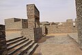 Open space
 A view of the ancient town of Tichit
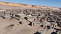 Some modern housing visible in the foreground with many other abandoned historical buildings


.jpg)
.jpg)
Climate
| Climate data for Tichit | |||||||||||||
|---|---|---|---|---|---|---|---|---|---|---|---|---|---|
| Month | Jan | Feb | Mar | Apr | May | Jun | Jul | Aug | Sep | Oct | Nov | Dec | Year |
| Mean daily maximum °C (°F) | 29.8 (85.6) | 32.9 (91.2) | 37.5 (99.5) | 40.4 (104.7) | 42.5 (108.5) | 42.0 (107.6) | 38.6 (101.5) | 35.8 (96.4) | 37.5 (99.5) | 38.7 (101.7) | 35.3 (95.5) | 31.6 (88.9) | 36.9 (98.4) |
| Mean daily minimum °C (°F) | 16.2 (61.2) | 19.2 (66.6) | 23.8 (74.8) | 26.9 (80.4) | 29.9 (85.8) | 30.5 (86.9) | 28.2 (82.8) | 26.6 (79.9) | 27.0 (80.6) | 27.0 (80.6) | 22.2 (72.0) | 18.1 (64.6) | 24.6 (76.4) |
| Average precipitation mm (inches) | 0 (0) | 1 (0.0) | 0 (0) | 1 (0.0) | 1 (0.0) | 6 (0.2) | 15 (0.6) | 32 (1.3) | 19 (0.7) | 3 (0.1) | 1 (0.0) | 0 (0) | 79 (2.9) |
| Source 1: http://www.storm247.com/weather/110676228/climate (temperature) | |||||||||||||
| Source 2: http://www.levoyageur.net/weather-city-TICHITT.html (precipitation) | |||||||||||||
References
Bibliography
- Holl, Augustin F.C. (2002), "Time, space, and image making: rock art from the Dhar Tichitt (Mauritania)" (PDF), African Archaeological Review, 19 (2): 75–118, doi:10.1023/A:1015479826570, hdl:2027.42/43991, JSTOR 25130740, S2CID 54741966.
- Holl, Augustin F.C. (2009), "Coping with uncertainty: Neolithic life in the Dhar Tichitt-Walata, Mauritania, (ca. 4000–2300 BP)", Comptes Rendus Geoscience, 341 (8–9): 703–712, doi:10.1016/j.crte.2009.04.005.
- Munson, Patrick J. (1980), "Archaeology and the prehistoric origins of the Ghana Empire", Journal of African History, 21 (4): 457–466, doi:10.1017/s0021853700018685, JSTOR 182004, S2CID 161981607.
Further reading
- Holl, Augustin (1985). "Subsistence patterns of the Neolithic, Mauritania". African Archaeological Review. 3: 151–162. doi:10.1007/bf01117458. JSTOR 25130453.
- Holl, Augustin F.C. (1998). "Livestock husbandry, pastoralisms, and territoriality: the West African record". Journal of Anthropological Archaeology. 17 (2): 143–165. doi:10.1006/jaar.1998.0321.
- MacDonald, Kevin; Vernet, Robert; Fuller, Dorian; Woodhouse, James (2003). "New light on the Tichitt tradition: A preliminary report on survey and excavation at Dhar Nema" (PDF). Oxford University School of Archaeology Monograph. 57: 73–80.
External links
- Map showing Tichit: Fond Typographique 1:200,000, République Islamique de Mauritanie Sheet NE-29-XV