Seabegs Wood was the site of a Roman fortlet on the Antonine Wall in Scotland.[1]
| Seabegs Wood | |
|---|---|
 | |
 Location in Central Scotland  Location in Scotland | |
| Founded during the reign of | Antoninus Pius |
| Founded | 142 AD |
| Place in the Roman world | |
| Province | Britannia |
| Structure | |
| — Turf structure — | |
| Location | |
| Coordinates | 55°59′33″N 3°53′58″W / 55.99241°N 3.8995°W |
| Town | Bonnybridge |
| County | Falkirk |
| Country | Scotland |
| Site notes | |
| Condition | Ruined |
At Seabegs, the outline of Antonine's Wall, has lasted.[2] Archaeologists from previous generations recorded this and stated that the ditch was deep and waterlogged.[3]
There is an underpass under the Forth and Clyde Canal nearby known locally as the Pend.[4]
In the 1890s, the Antonine Wall Committee of Glasgow Archaeological Society's cut several trenches across the Roman rampart. These uncovered its stone base. Subsequent excavations in 1977 found a Roman fortlet attached to the south of the Rampart. In 1981, a mound was examined but little has been discovered. Seabegs Wood was a portion of the ancient Barony of Seabegs. Seabegs Wood is part of a UNESCO World Heritage Site representing the best preserved portion of the ancient Roman Antonine Wall. The Seabegs Collection of Ancient Roman Coinage was donated to Dalhousie University, Halifax, Nova Scotia, Canada to commemorate this connection and consists of gold, silver and bronze portrait coinage depicting the majority of the ancient Roman emperors.
The forts to this fortlet are Castlecary in the west and Rough Castle in the east. Sir George Macdonald and others theorized that because these neighbouring forts were relatively widespread another structure was likely in the Seabegs area.[5]
No coinage has been recovered nor any inscriptions. There are two marching camps nearby at Dalnair and Milnquarter.[6]
Many Roman forts along the wall held garrisons of around 500 men.[7] Larger forts like Castlecary and Birrens had a nominal cohort of 1000 men[8] but probably sheltered women and children[9] as well although the troops were not allowed to marry.[10] There is likely too to have been large communities of civilians around the site.[11]
![The Wall, The Road and The Forth and Clyde Canal at Seabegs Wood[12]](//upload.wikimedia.org/wikipedia/commons/thumb/2/2e/The_Wall%2C_The_Road_and_The_Canal_-_geograph.org.uk_-_1747771.jpg/269px-The_Wall%2C_The_Road_and_The_Canal_-_geograph.org.uk_-_1747771.jpg) The Wall, The Road and The Forth and Clyde Canal at Seabegs Wood[12]
The Wall, The Road and The Forth and Clyde Canal at Seabegs Wood[12]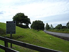 Seabegs Wood and the Antonine Wall between Bonnybridge and Allandale
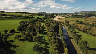 Antonine Wall West of Bonnybridge
![The Wall, The Road and The Forth and Clyde Canal at Seabegs Wood[12]](https://www.search.com.vn/wiki/en/File:The_Wall,_The_Road_and_The_Canal_-_geograph.org.uk_-_1747771.jpg)


