The Río Grande de Arecibo (Arecibo River) is a river of Puerto Rico. The headwaters lie in the mountains to the south of Adjuntas. From there it flows north until it reaches the Atlantic Ocean near Arecibo.[1] The tributaries lie along the side of the Cerro de Punta and the Utuado pluton. It flows through the northern, passing along a gorge that is 200 m deep and 800–1,200 m wide. It flows through the middle of Puerto Rico.[2]
| Arecibo River | |
|---|---|
 Río Grande de Arecibo | |
| Etymology | After the town of Arecibo, itself named after the Taíno cacique Arasibo and/or Taíno "arasiba" possibly meaning 'people's stone'. |
| Native name | Río Grande de Arecibo (Spanish) |
| Location | |
| Commonwealth | Puerto Rico |
| Municipality | Arecibo, Utuado |
| Physical characteristics | |
| Source | |
| • location | Depending on the definition near Utuado Pueblo at the junction of the Viví and the Pellejas Rivers or Dos Bocas Lake between Arecibo and Utuado |
| • coordinates | 18°28′22″N 66°42′38″W / 18.47278°N 66.71056°W |
| Mouth | |
• location | Arecibo Bay in the Atlantic Ocean near Arecibo Pueblo |
| Length | 52.89 km (32.86 mi) |
| Basin features | |
| Tributaries | |
| • left | Caguana River, Jobos Creek, Tanamá River |
| • right | Júa Creek, Caonillas River, Limón River, Vacas River |
The tributaries to Río Grande de Arecibo basin are Vacas, Pellejas, Garzas, Saltillo, Cidra, Grande de Jayuya, Caguana, Caonillas, Yunés, Limón, Jauca, Tanamá and Santiago rivers.[3]
Flood control project
In mid 2018, the United States Army Corps of Engineers announced it would be undertaking a major flood control project of the river, with a budget of $82.9 million.[4]
In mid 2021, funding was appropriated for work on the Río Grande de Arecibo, including work to improve the natural habitat of local species, including the Puerto Rican crested toad and a Río Grande de Arecibo canalization project was set to begin in 2023.[5][6]
Gallery
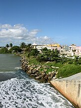 View of Arecibo from the mouth of Río Grande de Arecibo
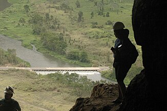 View of the river from Cueva Ventana
 Río Grande de Arecibo from Cueva Ventana after it rained


See also
- Cambalache Bridge: NRHP listing in Arecibo, Puerto Rico
- List of rivers of Puerto Rico