| [2] | Name on the Register | Image | Date listed[3] | Location | City or town | Description |
|---|
| 1 | Bank of Jersey | 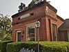 Bank of Jersey Bank of Jersey | March 7, 1984
(#84001269) | Main St.
33°43′01″N 83°47′59″W / 33.716944°N 83.799722°W / 33.716944; -83.799722 (Bank of Jersey) | Jersey | |
|---|
| 2 | A. J. Boss House | Upload image | December 28, 1983
(#83003609) | 324 Edwards St.
33°47′54″N 83°42′34″W / 33.798333°N 83.709444°W / 33.798333; -83.709444 (A. J. Boss House) | Monroe | |
|---|
| 3 | Samuel H. Brodnax House | Upload image | June 17, 1982
(#82002496) | GA 81
33°44′26″N 83°51′08″W / 33.740556°N 83.852222°W / 33.740556; -83.852222 (Samuel H. Brodnax House) | Walnut Grove | |
|---|
| 4 | Tom Chick House | Upload image | December 28, 1983
(#83003610) | 1102 E. Church St.
33°47′23″N 83°41′40″W / 33.789722°N 83.694444°W / 33.789722; -83.694444 (Tom Chick House) | Monroe | |
|---|
| 5 | Davis-Edwards House |  Davis-Edwards House Davis-Edwards House | August 14, 1973
(#73000648) | 238 N. Broad St.
33°47′50″N 83°42′48″W / 33.797222°N 83.713333°W / 33.797222; -83.713333 (Davis-Edwards House) | Monroe | |
|---|
| 6 | East Church Street Historic District | Upload image | December 28, 1983
(#83003612) | E. Church St. and S. Madison Ave.
33°47′30″N 83°42′23″W / 33.791667°N 83.706389°W / 33.791667; -83.706389 (East Church Street Historic District) | Monroe | |
|---|
| 7 | East Marable Street Historic District | Upload image | December 28, 1983
(#83003613) | E. Marable St.
33°48′11″N 83°42′49″W / 33.803056°N 83.713611°W / 33.803056; -83.713611 (East Marable Street Historic District) | Monroe | |
|---|
| 8 | William Harris Family Farmstead |  William Harris Family Farmstead William Harris Family Farmstead | June 22, 1982
(#82002494) | GA 11
33°53′38″N 83°43′23″W / 33.893889°N 83.723056°W / 33.893889; -83.723056 (William Harris Family Farmstead) | Campton | |
|---|
| 9 | Walter Jones Rock House |  Walter Jones Rock House Walter Jones Rock House | November 4, 1993
(#93001190) | 4435 GA 186 NE
33°47′48″N 83°33′02″W / 33.796667°N 83.550556°W / 33.796667; -83.550556 (Walter Jones Rock House) | Good Hope | |
|---|
| 10 | McDaniel Street Historic District | Upload image | December 28, 1983
(#83003614) | S. Broad and McDaniel Sts.
33°47′27″N 83°42′56″W / 33.790833°N 83.715556°W / 33.790833; -83.715556 (McDaniel Street Historic District) | Monroe | |
|---|
| 11 | McDaniel-Tichenor House |  McDaniel-Tichenor House McDaniel-Tichenor House | February 8, 1980
(#80001255) | 319 McDaniel St.
33°47′24″N 83°42′55″W / 33.79°N 83.715278°W / 33.79; -83.715278 (McDaniel-Tichenor House) | Monroe | |
|---|
| 12 | Monland Place Historic District | Upload image | December 28, 1983
(#83003616) | Alvoca St. and Blvd.
33°47′15″N 83°42′51″W / 33.7875°N 83.714167°W / 33.7875; -83.714167 (Monland Place Historic District) | Monroe | |
|---|
| 13 | Monroe and Walton Mills Historic District | Upload image | December 28, 1983
(#83003617) | S. Broad St., S. Madison Ave., and Georgia RR line
33°47′05″N 83°42′33″W / 33.784722°N 83.709167°W / 33.784722; -83.709167 (Monroe and Walton Mills Historic District) | Monroe | |
|---|
| 14 | Monroe City Hall | 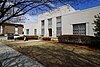 Monroe City Hall Monroe City Hall | December 28, 1983
(#83003618) | 227 S. Broad St.
33°47′33″N 83°42′45″W / 33.7925°N 83.7125°W / 33.7925; -83.7125 (Monroe City Hall) | Monroe | |
|---|
| 15 | Monroe Commercial Historic District |  Monroe Commercial Historic District Monroe Commercial Historic District | December 28, 1983
(#83003619) | Spring and Broad Sts.
33°47′40″N 83°42′46″W / 33.794444°N 83.712778°W / 33.794444; -83.712778 (Monroe Commercial Historic District) | Monroe | |
|---|
| 16 | North Broad Street Historic District | Upload image | December 28, 1983
(#83003623) | N. Broad and Walton Sts.
33°47′50″N 83°42′54″W / 33.797222°N 83.715°W / 33.797222; -83.715 (North Broad Street Historic District) | Monroe | |
|---|
| 17 | Social Circle Historic District | Upload image | March 27, 1980
(#80001257) | GA 11 and GA 229
33°39′19″N 83°43′08″W / 33.655278°N 83.718889°W / 33.655278; -83.718889 (Social Circle Historic District) | Social Circle | |
|---|
| 18 | South Broad Street Historic District | Upload image | December 28, 1983
(#83003620) | S. Broad St.
33°47′20″N 83°42′40″W / 33.788889°N 83.711111°W / 33.788889; -83.711111 (South Broad Street Historic District) | Monroe | |
|---|
| 19 | South Madison Avenue-Pannell Road Historic District | Upload image | December 28, 1983
(#83003621) | S. Madison Ave. and Pannell Rd.
33°46′35″N 83°42′00″W / 33.776389°N 83.7°W / 33.776389; -83.7 (South Madison Avenue-Pannell Road Historic District) | Monroe | |
|---|
| 20 | James Berrien Upshaw House |  James Berrien Upshaw House James Berrien Upshaw House | March 6, 1986
(#86000414) | US 78/GA 11
33°49′02″N 83°48′28″W / 33.817222°N 83.807778°W / 33.817222; -83.807778 (James Berrien Upshaw House) | Between | |
|---|
| 21 | Walton County Courthouse |  Walton County Courthouse Walton County Courthouse | September 18, 1980
(#80001256) | Courthouse Sq.
33°47′40″N 83°42′45″W / 33.794444°N 83.7125°W / 33.794444; -83.7125 (Walton County Courthouse) | Monroe | |
|---|
| 22 | Walton County Jail | 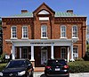 Walton County Jail Walton County Jail | December 28, 1983
(#83003624) | 203 Milledge Ave.
33°47′37″N 83°42′33″W / 33.793611°N 83.709167°W / 33.793611; -83.709167 (Walton County Jail) | Monroe | |
|---|
| 23 | Walton Hotel | Upload image | July 15, 1982
(#82002495) | Broad and Court Sts.
33°47′38″N 83°42′47″W / 33.793889°N 83.713056°W / 33.793889; -83.713056 (Walton Hotel) | Monroe | |
|---|
| 24 | Williamson House | 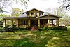 Williamson House Williamson House | December 28, 1983
(#83003625) | 925 E. Church St.
33°47′34″N 83°41′54″W / 33.792778°N 83.698333°W / 33.792778; -83.698333 (Williamson House) | Monroe | |
|---|


.jpg)


.jpg)


.jpg)