National Register of Historic Places listings in Scott County, Arkansas


This is a list of the National Register of Historic Places listings in Scott County, Arkansas.
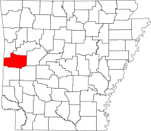
Location of Scott County in Arkansas

This is intended to be a complete list of the properties and districts on the National Register of Historic Places in Scott County, Arkansas, United States. The locations of National Register properties and districts for which the latitude and longitude coordinates are included below, may be seen in a map.[1]

There are 14 properties and districts listed on the National Register in the county.

Contents: Counties in Arkansas


          This National Park Service list is complete through NPS recent listings posted June 28, 2024.[2]

Current listings

[3]Name on the Register[4]ImageDate listed[5]Location City or townDescription
1Bates School
Bates School
February 21, 2006
(#06000081)
1074 Bates School Rd.
34°54′24″N 94°22′53″W / 34.9067°N 94.3814°W / 34.9067; -94.3814 (Bates School)
Bates
2Cold Spring
Cold Spring
October 21, 1993
(#93001082)
County Road 93 northeast of Waldron in the Ouachita National Forest
34°57′39″N 93°53′31″W / 34.9608°N 93.8919°W / 34.9608; -93.8919 (Cold Spring)
Waldron
3Dooley Dipping VatJune 7, 2006
(#06000466)
Off Dooley Rd. east of Forest Service Road 925
34°46′00″N 94°01′10″W / 34.7667°N 94.0194°W / 34.7667; -94.0194 (Dooley Dipping Vat)
Boles
4C.E. Forrester House
C.E. Forrester House
September 3, 1998
(#98001127)
140 Danville Rd.
34°53′55″N 94°05′02″W / 34.8986°N 94.0839°W / 34.8986; -94.0839 (C.E. Forrester House)
Waldron
5Mount Pleasant Methodist Church
Mount Pleasant Methodist Church
June 5, 1986
(#86001207)
Highway 248
34°55′22″N 94°01′26″W / 34.9228°N 94.0239°W / 34.9228; -94.0239 (Mount Pleasant Methodist Church)
Waldron
6Parks School
Parks School
June 6, 2002
(#02000602)
Highway 28
34°48′11″N 93°57′34″W / 34.8031°N 93.9594°W / 34.8031; -93.9594 (Parks School)
Parks
7Poteau Work Center
Poteau Work Center
October 20, 1993
(#93001094)
Poteau Work Center access road off Highway 80
34°53′40″N 94°04′06″W / 34.8944°N 94.0683°W / 34.8944; -94.0683 (Poteau Work Center)
Waldron
8Poteau Work Center Residence No. 2
Poteau Work Center Residence No. 2
October 20, 1993
(#93001095)
Poteau Work Center access road off Highway 80
34°53′41″N 94°04′09″W / 34.8947°N 94.0692°W / 34.8947; -94.0692 (Poteau Work Center Residence No. 2)
Waldron
9Powder MagazineOctober 20, 1993
(#93001096)
County Road 96 north of Blue Ball, Ouachita National Forest
35°00′08″N 93°43′07″W / 35.0022°N 93.7186°W / 35.0022; -93.7186 (Powder Magazine)
Blue Ball
10Scott City County Jail, (Old)
Scott City County Jail, (Old)
May 16, 2002
(#02000486)
125 W. 2nd St.
34°53′56″N 94°05′29″W / 34.8989°N 94.0914°W / 34.8989; -94.0914 (Scott City County Jail, (Old))
Waldron
11Scott County Courthouse
Scott County Courthouse
November 13, 1989
(#89001971)
Courthouse Square[6]
34°53′57″N 94°05′30″W / 34.8992°N 94.0917°W / 34.8992; -94.0917 (Scott County Courthouse)
Waldron
12Square Rock Dipping VatJune 7, 2006
(#06000464)
Northwest of the junction of Forest Service Roads 296 and 565A
34°57′32″N 93°59′42″W / 34.9589°N 93.995°W / 34.9589; -93.995 (Square Rock Dipping Vat)
Waldron
13Waldron Commercial Historic District
Waldron Commercial Historic District
September 25, 2008
(#08000943)
S. Main St. between 1st and 5th Sts. and Washington St. between 2nd and 3rd Sts.
34°53′57″N 94°05′28″W / 34.8991°N 94.0912°W / 34.8991; -94.0912 (Waldron Commercial Historic District)
Waldron
14Waldron School Historic DistrictSeptember 27, 2019
(#100004437)
403 and 429 W. 5th St.
34°53′51″N 94°05′45″W / 34.8974°N 94.0957°W / 34.8974; -94.0957 (Waldron School Historic District)
Waldron

Former listings

[3]Name on the RegisterImageDate listedDate removedLocation City or townDescription
1John T. Forrester HouseDecember 8, 1980
(#80000786)
October 18, 2002115 Danville Street
Waldron

See also

References