| [3] | Name on the Register | Image | Date listed[4] | Location | City or town | Description |
|---|
| 1 | Bachelor's Hope |  Bachelor's Hope Bachelor's Hope | May 3, 1984
(#84001855) | Maryland Route 18
39°02′01″N 76°06′18″W / 39.033611°N 76.105°W / 39.033611; -76.105 (Bachelor's Hope) | Centreville | |
|---|
| 2 | Bishopton |  Bishopton Bishopton | September 12, 1985
(#85002194) | Pinder Hill Rd.
39°09′35″N 75°58′26″W / 39.159722°N 75.973889°W / 39.159722; -75.973889 (Bishopton) | Church Hill | |
|---|
| 3 | Bloomingdale | 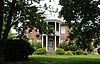 Bloomingdale Bloomingdale | October 18, 1972
(#72001457) | Bloomingdale Rd. and U.S. Route 50
38°58′21″N 76°07′01″W / 38.9725°N 76.116944°W / 38.9725; -76.116944 (Bloomingdale) | Queenstown | |
|---|
| 4 | Bowlingly |  Bowlingly Bowlingly | August 21, 1972
(#72001458) | Off Maryland Route 18
38°59′36″N 76°09′30″W / 38.993333°N 76.158333°W / 38.993333; -76.158333 (Bowlingly) | Queenstown | |
|---|
| 5 | Captain's Houses |  Captain's Houses Captain's Houses | November 17, 1980
(#80001830) | Corsica St.
39°03′07″N 76°04′32″W / 39.051944°N 76.075556°W / 39.051944; -76.075556 (Captain's Houses) | Centreville | |
|---|
| 6 | Centreville Armory | 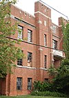 Centreville Armory Centreville Armory | September 25, 1985
(#85002666) | S. Commerce St.
39°02′30″N 76°04′05″W / 39.041667°N 76.068056°W / 39.041667; -76.068056 (Centreville Armory) | Centreville | |
|---|
| 7 | Centreville Historic District |  Centreville Historic District Centreville Historic District | November 13, 2004
(#04001218) | Roughly bounded by the Corsica River, Chesterfield Ave, Liberty St, Banjo Ln, Railroad Ave, town limits, and Mill Stream
39°02′45″N 76°04′02″W / 39.045833°N 76.067222°W / 39.045833; -76.067222 (Centreville Historic District) | Centreville | |
|---|
| 8 | Chester Hall |  Chester Hall Chester Hall | January 18, 1980
(#80001831) | 1 mile southeast of Chestertown on Maryland Route 213
39°12′17″N 76°02′43″W / 39.204722°N 76.045278°W / 39.204722; -76.045278 (Chester Hall) | Chestertown | |
|---|
| 9 | Christ Church |  Christ Church Christ Church | July 24, 1979
(#79003268) | Maryland Route 18
38°58′50″N 76°18′52″W / 38.980556°N 76.314444°W / 38.980556; -76.314444 (Christ Church) | Stevensville | |
|---|
| 10 | Churchill Theatre-Community Building |  Churchill Theatre-Community Building Churchill Theatre-Community Building | September 8, 2000
(#00001051) | Maryland Route 19
39°08′31″N 75°59′06″W / 39.141944°N 75.985°W / 39.141944; -75.985 (Churchill Theatre-Community Building) | Church Hill | |
|---|
| 11 | Jackson Collins House | 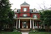 Jackson Collins House Jackson Collins House | December 13, 2000
(#00001503) | 201 S. Commerce St.
39°02′34″N 76°03′58″W / 39.04285°N 76.06609°W / 39.04285; -76.06609 (Jackson Collins House) | Centreville | |
|---|
| 12 | Content |  Content Content | February 13, 1986
(#86000256) | Maryland Route 305 near Tanyard Rd.
39°02′30″N 76°01′17″W / 39.041667°N 76.021389°W / 39.041667; -76.021389 (Content) | Centreville | |
|---|
| 13 | Cray House |  Cray House Cray House | May 9, 1983
(#83002960) | Cockey's Lane
38°58′53″N 76°18′56″W / 38.981389°N 76.315556°W / 38.981389; -76.315556 (Cray House) | Stevensville | |
|---|
| 14 | Delaware Boundary Markers | Upload image | February 18, 1975
(#75002101) | Boundary line dividing Delaware from Maryland and Pennsylvania
Coordinates missing | Multiple | Extends into Delaware and southeastern Pennsylvania. |
|---|
| 15 | Dudley's Chapel |  Dudley's Chapel Dudley's Chapel | November 15, 1979
(#79003124) | Southwest of Sudlersville off Maryland Route 300
39°10′56″N 75°53′33″W / 39.182222°N 75.8925°W / 39.182222; -75.8925 (Dudley's Chapel) | Sudlersville | |
|---|
| 16 | John Embert Farm |  John Embert Farm John Embert Farm | June 22, 1980
(#80001832) | Southeast of Millington on Baxter Rd., 0.6 miles east of Peters Comer Rd.
39°13′30″N 75°48′40″W / 39.225°N 75.811111°W / 39.225; -75.811111 (John Embert Farm) | Millington | |
|---|
| 17 | Female Seminary |  Female Seminary Female Seminary | December 10, 2003
(#03001266) | 205-207 S. Commerce St.
39°02′32″N 76°03′59″W / 39.04234°N 76.06639°W / 39.04234; -76.06639 (Female Seminary) | Centreville | |
|---|
| 18 | Friendship |  Friendship Friendship | July 15, 1994
(#94000727) | 200 Friendship Manor Dr.
38°57′12″N 76°20′43″W / 38.953333°N 76.345278°W / 38.953333; -76.345278 (Friendship) | Stevensville | |
|---|
| 19 | Hawkins Pharsalia |  Hawkins Pharsalia Hawkins Pharsalia | December 20, 1984
(#84000458) | Maryland Route 304
39°01′02″N 75°55′06″W / 39.017222°N 75.918333°W / 39.017222; -75.918333 (Hawkins Pharsalia) | Ruthsburg | |
|---|
| 20 | Keating House |  Keating House Keating House | October 28, 1999
(#99001281) | 208 S. Liberty St.
39°02′35″N 76°04′05″W / 39.04298°N 76.06796°W / 39.04298; -76.06796 (Keating House) | Centreville | |
|---|
| 21 | Kennersley |  Kennersley Kennersley | May 19, 1983
(#83002961) | Clabber Hill Rd.
39°08′46″N 76°01′58″W / 39.146111°N 76.032778°W / 39.146111; -76.032778 (Kennersley) | Church Hill | |
|---|
| 22 | Lansdowne |  Lansdowne Lansdowne | June 7, 1984
(#84001858) | Maryland Route 305
39°02′49″N 75°59′26″W / 39.046944°N 75.990556°W / 39.046944; -75.990556 (Lansdowne) | Centreville | |
|---|
| 23 | Legg's Dependence |  Legg's Dependence Legg's Dependence | November 8, 2003
(#03001116) | 0200 Long Creek Court
38°55′13″N 76°20′46″W / 38.920278°N 76.346111°W / 38.920278; -76.346111 (Legg's Dependence) | Stevensville | |
|---|
| 24 | Lexon | 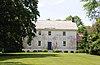 Lexon Lexon | May 4, 1990
(#90000726) | Corsica Neck Rd. southwest of Earle Cove
39°03′16″N 76°05′15″W / 39.054444°N 76.0875°W / 39.054444; -76.0875 (Lexon) | Centreville | |
|---|
| 25 | Mattapax |  Mattapax Mattapax | December 10, 1998
(#98001498) | 106 Shipping Creek Rd.
38°54′40″N 76°20′54″W / 38.911111°N 76.348333°W / 38.911111; -76.348333 (Mattapax) | Stevensville | |
|---|
| 26 | MYSTERY (log canoe) | Upload image | September 18, 1985
(#85002250) | Round Top Rd.
39°12′29″N 76°02′16″W / 39.208056°N 76.037778°W / 39.208056; -76.037778 (MYSTERY (log canoe)) | Kingstown | |
|---|
| 27 | Capt. John H. Ozmon Store | 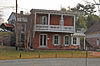 Capt. John H. Ozmon Store Capt. John H. Ozmon Store | February 14, 1985
(#85000277) | Centreville Wharf
39°03′12″N 76°04′28″W / 39.053333°N 76.074444°W / 39.053333; -76.074444 (Capt. John H. Ozmon Store) | Centreville | |
|---|
| 28 | Readbourne |  Readbourne Readbourne | April 11, 1973
(#73002134) | 5.4 miles northwest of Centreville
39°07′38″N 76°05′26″W / 39.127222°N 76.090556°W / 39.127222; -76.090556 (Readbourne) | Centreville | |
|---|
| 29 | Reed's Creek Farm |  Reed's Creek Farm Reed's Creek Farm | July 7, 1975
(#75002106) | West of Centreville on Wright's Neck Rd. off Maryland Route 18
39°03′05″N 76°09′12″W / 39.051389°N 76.153333°W / 39.051389; -76.153333 (Reed's Creek Farm) | Centreville | |
|---|
| 30 | St. Andrew's Episcopal Chapel |  St. Andrew's Episcopal Chapel St. Andrew's Episcopal Chapel | September 7, 1984
(#84001853) | Church St. and Maple Ave.
39°11′06″N 75°51′30″W / 39.185°N 75.858333°W / 39.185; -75.858333 (St. Andrew's Episcopal Chapel) | Sudlersville | |
|---|
| 31 | St. Luke's Church | 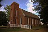 St. Luke's Church St. Luke's Church | November 23, 1977
(#77001505) | Junction of Maryland Routes 19 and 213
39°08′32″N 75°59′11″W / 39.142222°N 75.986389°W / 39.142222; -75.986389 (St. Luke's Church) | Church Hill | |
|---|
| 32 | St. Peter's Church |  St. Peter's Church St. Peter's Church | March 10, 1980
(#80001833) | Southeast of Queenstown on U.S. Route 50
38°58′41″N 76°08′03″W / 38.978056°N 76.134167°W / 38.978056; -76.134167 (St. Peter's Church) | Queenstown | |
|---|
| 33 | Starr Church | Upload image | March 1, 2024
(#100009979) | 1504 Starr Road
38°58′31″N 76°00′26″W / 38.9754°N 76.00734°W / 38.9754; -76.00734 (Starr Church) | Centreville | |
|---|
| 34 | Stevensville Bank |  Stevensville Bank Stevensville Bank | January 3, 1985
(#85000020) | Love Point Rd.
38°58′55″N 76°18′53″W / 38.981944°N 76.314722°W / 38.981944; -76.314722 (Stevensville Bank) | Stevensville | |
|---|
| 35 | Stevensville Historic District | 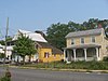 Stevensville Historic District Stevensville Historic District | September 11, 1986
(#86002333) | Maryland Route 18 and Love Point Rd.
38°58′53″N 76°18′49″W / 38.981389°N 76.313611°W / 38.981389; -76.313611 (Stevensville Historic District) | Stevensville | |
|---|
| 36 | Stratton |  Stratton Stratton | December 18, 2003
(#03001294) | 3102 Ruthsburg Rd.
39°01′41″N 75°53′51″W / 39.028056°N 75.8975°W / 39.028056; -75.8975 (Stratton) | Centreville | |
|---|
| 37 | Thomas House |  Thomas House Thomas House | May 13, 1976
(#76002150) | 1.8 miles northeast of Ruthsburg on Maryland Route 304
39°00′54″N 75°55′53″W / 39.015°N 75.931389°W / 39.015; -75.931389 (Thomas House) | Ruthsburg | |
|---|
| 38 | Wilton | 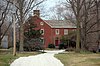 Wilton Wilton | December 12, 1977
(#77001506) | North of Wye Mills on Maryland Route 213
38°56′58″N 76°04′37″W / 38.949444°N 76.076944°W / 38.949444; -76.076944 (Wilton) | Wye Mills | |
|---|
| 39 | Wye Hall |  Wye Hall Wye Hall | November 2, 2015
(#15000759) | 505 Wye Hall Dr.
38°53′20″N 76°07′07″W / 38.8888°N 76.1187°W / 38.8888; -76.1187 (Wye Hall) | Queenstown | |
|---|
| 40 | Wye Mill | 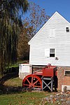 Wye Mill Wye Mill | April 9, 1985
(#85000717) | Maryland Route 662
38°56′29″N 76°04′53″W / 38.941389°N 76.081389°W / 38.941389; -76.081389 (Wye Mill) | Wye Mills | Extends into Talbot County |
|---|


_18.jpg)


_14.jpg)
_QUEEN_ANNES_COUNTY,_MD.jpg)


