| [2] | Name on the Register | Image | Date listed[3] | Location | City or town | Description |
|---|
| 1 | Alma Fruit Farm | Upload image | November 25, 1980
(#80004446) | GA 49W
32°26′13″N 84°00′04″W / 32.4369°N 84.0011°W / 32.4369; -84.0011 (Alma Fruit Farm) | Marshallville | Also known as the Jones-Peterson House. |
|---|
| 2 | Andersonville National Historic Site |  Andersonville National Historic Site Andersonville National Historic Site | October 16, 1970
(#70000070) | 1 mi. E of Andersonville on GA 49
32°11′41″N 84°07′44″W / 32.19469°N 84.12895°W / 32.19469; -84.12895 (Andersonville National Historic Site) | Andersonville | administered by the National Park Service |
|---|
| 3 | Billy Place | Upload image | November 25, 1980
(#80004444) | Rt. 1
32°25′10″N 83°57′44″W / 32.419444°N 83.962222°W / 32.419444; -83.962222 (Billy Place) | Marshallville | |
|---|
| 4 | DeVaughn-Lewis House | Upload image | May 2, 1985
(#85000937) | 510 S. Dooly St.
32°17′38″N 84°01′53″W / 32.293889°N 84.031389°W / 32.293889; -84.031389 (DeVaughn-Lewis House) | Montezuma | |
|---|
| 5 | East Main Street Residential District | Upload image | November 25, 1980
(#80004454) | E. Main St.
32°27′18″N 83°56′12″W / 32.455°N 83.936667°W / 32.455; -83.936667 (East Main Street Residential District) | Marshallville | |
|---|
| 6 | William Hamilton Felton House | Upload image | November 25, 1980
(#80004447) | McCaskill St.
32°26′50″N 83°57′02″W / 32.44731°N 83.95050°W / 32.44731; -83.95050 (William Hamilton Felton House) | Marshallville | |
|---|
| 7 | Wilkes Knob Plantation | Upload image | November 25, 1980
(#80004451) | Rt. 1
32°28′20″N 83°52′48″W / 32.47217°N 83.87995°W / 32.47217; -83.87995 (Wilkes Knob Plantation) | Marshallville | |
|---|
| 8 | Lamson-Richardson School | Upload image | May 18, 1981
(#81000697) | Railroad St.
32°26′49″N 83°56′40″W / 32.446944°N 83.944444°W / 32.446944; -83.944444 (Lamson-Richardson School) | Marshallville | |
|---|
| 9 | Macon County Courthouse | 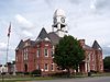 Macon County Courthouse Macon County Courthouse | September 18, 1980
(#80001113) | Courthouse Sq.
32°17′36″N 84°03′36″W / 32.29341°N 84.06001°W / 32.29341; -84.06001 (Macon County Courthouse) | Oglethorpe | |
|---|
| 10 | Marshallville Commercial District | Upload image | November 25, 1980
(#80004452) | Main St.
32°27′23″N 83°55′24″W / 32.456389°N 83.923333°W / 32.456389; -83.923333 (Marshallville Commercial District) | Marshallville | |
|---|
| 11 | Massee Lane | Upload image | November 25, 1980
(#80004450) | Rt. 1
32°29′17″N 83°56′09″W / 32.48803°N 83.93573°W / 32.48803; -83.93573 (Massee Lane) | Marshallville | |
|---|
| 12 | Montezuma Depot | 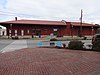 Montezuma Depot Montezuma Depot | June 12, 1980
(#80001112) | S. Dooly St.
32°18′02″N 84°01′46″W / 32.300556°N 84.029444°W / 32.300556; -84.029444 (Montezuma Depot) | Montezuma | |
|---|
| 13 | Montezuma Historic District | 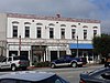 Montezuma Historic District Montezuma Historic District | October 13, 2003
(#03001017) | Roughly centered along N. and S. Dooly St.
32°18′11″N 84°01′47″W / 32.303056°N 84.029722°W / 32.303056; -84.029722 (Montezuma Historic District) | Montezuma | |
|---|
| 14 | Thronateeska | Upload image | November 25, 1980
(#80004445) | Rt. 1
32°25′14″N 84°00′59″W / 32.42050°N 84.01642°W / 32.42050; -84.01642 (Thronateeska) | Marshallville | Seems to be gone in recent satellite views |
|---|
| 15 | West Main Street Residential District | Upload image | November 25, 1980
(#80004453) | W. Main St.
32°27′21″N 83°56′59″W / 32.455833°N 83.949722°W / 32.455833; -83.949722 (West Main Street Residential District) | Marshallville | |
|---|
| 16 | Willow Lake | Upload image | November 25, 1980
(#80004449) | Rt. 1
32°28′36″N 83°53′25″W / 32.47654°N 83.89026°W / 32.47654; -83.89026 (Willow Lake) | Marshallville | |
|---|


.JPG)
