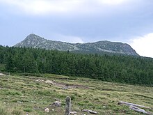
The Mont Mézenc (French pronunciation: [mezɛ̃]) is a summit of the Massif Central, France.

Description
Located at the altitude of 1753 m (5751 feet) - for the South Summit, and 1744 m (5722 feet) for the North Summit - in the department of Haute-Loire, Auvergne-Rhône-Alpes, France, it's the highest point of the department (and of the department of Ardèche). The Mont Mézenc has a volcanic origin.[1][2][3][4][5][6][7][8][9][10][11] It's a dome of phonolite dating 7 million years.
Climate
Mont Mézenc has a humid continental climate (Köppen Dfb), bordering on a subarctic climate (Köppen Dfc). Estables.sa is a weather station situated on the southern face of Mont d'Alambre, 1,691 metres (5,548 ft), approximately 1.5 kilometres (0.93 mi) from the North Summit of Mont Mézenc.
| Climate data for Mont Mézenc (Estables.sa), 1486m (1981−2010 normals, 1982−2010 extremes) | |||||||||||||
|---|---|---|---|---|---|---|---|---|---|---|---|---|---|
| Month | Jan | Feb | Mar | Apr | May | Jun | Jul | Aug | Sep | Oct | Nov | Dec | Year |
| Record high °C (°F) | 18.0 (64.4) | 16.6 (61.9) | 19.6 (67.3) | 20.3 (68.5) | 24.1 (75.4) | 31.0 (87.8) | 31.6 (88.9) | 31.4 (88.5) | 29.5 (85.1) | 22.9 (73.2) | 18.3 (64.9) | 17.4 (63.3) | 31.6 (88.9) |
| Mean daily maximum °C (°F) | 1.6 (34.9) | 1.7 (35.1) | 4.6 (40.3) | 7.4 (45.3) | 12.3 (54.1) | 16.4 (61.5) | 19.8 (67.6) | 19.5 (67.1) | 15.1 (59.2) | 10.8 (51.4) | 4.9 (40.8) | 2.5 (36.5) | 9.7 (49.5) |
| Daily mean °C (°F) | −1.2 (29.8) | −1.1 (30.0) | 1.3 (34.3) | 3.7 (38.7) | 8.3 (46.9) | 11.9 (53.4) | 14.9 (58.8) | 14.8 (58.6) | 11.0 (51.8) | 7.4 (45.3) | 2.1 (35.8) | −0.2 (31.6) | 6.1 (42.9) |
| Mean daily minimum °C (°F) | −3.9 (25.0) | −4.0 (24.8) | −2.1 (28.2) | −0.1 (31.8) | 4.2 (39.6) | 7.5 (45.5) | 10.0 (50.0) | 10.2 (50.4) | 6.9 (44.4) | 4.0 (39.2) | −0.7 (30.7) | −2.9 (26.8) | 2.4 (36.4) |
| Record low °C (°F) | −25.5 (−13.9) | −22.8 (−9.0) | −17.3 (0.9) | −10.5 (13.1) | −5.5 (22.1) | −1.6 (29.1) | 0.8 (33.4) | 0.0 (32.0) | −2.0 (28.4) | −9.8 (14.4) | −16.0 (3.2) | −18.2 (−0.8) | −25.5 (−13.9) |
| Average precipitation mm (inches) | 81.9 (3.22) | 72.9 (2.87) | 62.2 (2.45) | 117.1 (4.61) | 135.7 (5.34) | 92.8 (3.65) | 67.2 (2.65) | 88.8 (3.50) | 124.0 (4.88) | 138.5 (5.45) | 133.8 (5.27) | 83.1 (3.27) | 1,198 (47.16) |
| Source: Meteociel[12] | |||||||||||||

