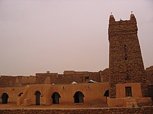
The United Nations Educational, Scientific and Cultural Organization (UNESCO) World Heritage Sites are places of importance to cultural or natural heritage as described in the UNESCO World Heritage Convention, established in 1972.[1] Mauritania ratified the convention on March 2, 1981, making its historical sites eligible for inclusion on the list. As of 2023, Mauritania has two world heritage sites[2]

Location of sites
List of Sites
| Name | Image | Location | Criteria | Year | Description |
|---|---|---|---|---|---|
| Banc d'Arguin National Park |  | Dakhlet Nouadhibou Region, Inchiri Region | Natural (ix) (x) | 1989 | Fringing the Atlantic coast, the park comprises sand-dunes, coastal swamps, small islands and shallow coastal waters. The contrast between the harsh desert environment and the biodiversity of the marine zone has resulted in a land- and seascape of outstanding natural significance. A wide variety of migrating birds spend the winter there. Several species of sea turtle and dolphin, used by the fishermen to attract shoals of fish, can also be found.[3] |
| Ancient Ksour of Ouadane, Chinguetti, Tichitt and Oualata |  | Adrar Region, Hodh Ech Chargui, Tagant Region | Cultural (iii) (iv) (v) | 1996 | Founded in the 11th and 12th centuries to serve the caravans crossing the Sahara, these trading and religious centres became focal points of Islamic culture. They have managed to preserve an urban fabric that evolved between the 12th and 16th centuries. Typically, houses with patios crowd along narrow streets around a mosque with a square minaret. They illustrate a traditional way of life centred on the nomadic culture of the people of the western Sahara.[4] |
Tentative List
| Site | Image | Location | Criteria | Area ha (acre) | Year of submission | Description |
|---|---|---|---|---|---|---|
| Azougui Cultural Landscape |  | Adrar Region20°24′19″N 13°06′40″W / 20.405278°N 13.111111°W | Cultural (iii) (iv) (v) (vi) | 2001 | [5] | |
| Kumbi Saleh Archaeological Site |  | Hodh Ech Chargui Region 15°45′56″N 7°58′07″W / 15.765556°N 7.968611°W | Cultural (iii) (iv) (v) (vi) | 2001 | [6] | |
| Tegdaoust Archaeological Site |  | Hodh El Gharbi Region 17°25′00″N 10°25′00″W / 17.416667°N 10.416667°W | Cultural (iii) (v) | 2001 | [7] |
References
🔥 Top keywords: Main PageSpecial:SearchPage 3Wikipedia:Featured picturesHouse of the DragonUEFA Euro 2024Bryson DeChambeauJuneteenthInside Out 2Eid al-AdhaCleopatraDeaths in 2024Merrily We Roll Along (musical)Jonathan GroffJude Bellingham.xxx77th Tony AwardsBridgertonGary PlauchéKylian MbappéDaniel RadcliffeUEFA European Championship2024 ICC Men's T20 World CupUnit 731The Boys (TV series)Rory McIlroyN'Golo KantéUEFA Euro 2020YouTubeRomelu LukakuOpinion polling for the 2024 United Kingdom general electionThe Boys season 4Romania national football teamNicola CoughlanStereophonic (play)Gene WilderErin DarkeAntoine GriezmannProject 2025


