The Chicago "L" is a rapid transit system that serves the city of Chicago and seven of its surrounding suburbs. The system is operated by the Chicago Transit Authority (CTA). On an average weekday, 759,866 passengers ride the "L",[1] making it the second-busiest rapid transit system in the United States, behind the New York City Subway.[2]

The system began as three separate companies, which built lines traveling from Chicago's central business district to the south and the west. The first of these was the Chicago and South Side Rapid Transit Railroad which opened on June 6, 1892.[3] The Lake Street Elevated Railroad opened the following year and the Metropolitan West Side Elevated Railroad followed in 1895. Initially, the "L" lines operated independently of each other, but in 1897, they were combined into one physically unified system with the completion of the Union Loop and connecting trackage.[4] In 1900, the Northwestern Elevated Railroad entered operation,[5] finalizing the basic structure of the system: a hub and spoke distribution paradigm radiating north, west, and south from downtown Chicago. The system expanded outward from this with new branches or line extensions until 1930.
Due to the ruined financial state of the privately owned Chicago Rapid Transit Company and the Chicago Surface Lines, a public agency (the CTA) was created in 1947 to take over and save the rapid transit and streetcar systems.[6] Starting in 1948, the CTA began systematically shutting down many stations and lines that saw little use in order to improve service and reduce costs. Expansion resumed in September 1969 with the opening of a new line in the median of the Dan Ryan Expressway and continued until October 31, 1993, with the opening of the Orange Line.[7] The newest line the Pink Line, which opened on June 25, 2006 was created by rerouting the Blue Line's Douglas branch into a separate service.[8]
As of March 2021[update], the system has 145 stations on eight lines operating on 224.1 miles (360.7 km) of track.[1] A total of 103 stations are compliant with the Americans with Disabilities Act of 1990 and are accessible to passengers with disabilities.[9] The majority of "L" stations are named for the streets or intersections on which they are located; others are named for neighborhoods, suburbs, destinations, or a combination of these.[10] The newest station is Washington/Wabash, which opened on August 31, 2017.[11]
Lines
| Line | Stations | Termini | Weekday ridership (as of July 2022)[12] |
|---|---|---|---|
| Blue | 33 | O'Hare Rosemont (north, select weekday rush hour trains) Jefferson Park (north, select weekday rush hour trains) Forest Park (south, all other trains) UIC-Halsted (south, select weekday rush hour trains)[13] | 66,838 |
| Brown | 27 | Kimball (north) The Loop (south, all except nights) Belmont (south, late nights)[14] | 29,531 |
| Green | 30 | Harlem/Lake (north) Cottage Grove (south via East 63rd branch) Ashland/63rd (south via Ashland branch) | 20,219 |
| Orange | 16 | The Loop[15] Midway | 15,129 |
| Pink | 22 | 54th/Cermak (west) The Loop (east) | 9,834 |
| Purple | 26 | Linden (north) Howard (south, shuttle service) The Loop (south, weekday rush hour express service) | 4,558 |
| Red | 33 | Howard (north) 95th/Dan Ryan (south) | 98,148 |
| Yellow | 3 | Dempster–Skokie (west) Howard (east) | 1,212 |
Stations
|


Gallery
 North/Clybourn is the only station on the Red Line's subway component with fare controls above ground
 One of several stations built on ground level, Oakton–Skokie has head houses built at each end
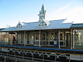 The twin head houses of Conservatory–Central Park Drive date back to 1894
 The Midway terminal features both an island platform and a side platform
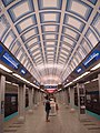 The island platform at Jackson/Dearborn conforms to the same structure that all the subway platforms in the Loop have
 Noyes, unlike most stations, has a platform that is only long enough for six cars instead of the usual eight
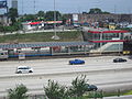 Pedestrian access to 63rd is from the bridge spanning the Dan Ryan expressway. Most stations built in highway medians on the Chicago "L" are reached in this way
 Like many stations, Ashland/63rd is an elevated station. Accessibility is provided via an elevator to the station's platform
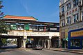 Argyle is one of several stations built on a concrete embankment


Planned stations
| Station | Lines | Transfers | Location | Planned opening | Structure | Status |
|---|---|---|---|---|---|---|
Damen  | Green | — | Near West Side | 2024[75] | Elevated | Under construction[76] |
| 103rd | Red | — | Roseland/Washington Heights | December 2029[77] | Elevated | Proposed |
| 111th | Red | — | Roseland | December 2029[77] | Elevated | Proposed |
| 130th † | Red | — | Riverdale | December 2029[77] | At-grade | Proposed |
| Michigan | Red | — | West Pullman | December 2029[77] | Elevated | Proposed |
Notes
- a On May 16, 1908, the Northwestern Elevated Railroad's rapid transit service replaced the service of the Milwaukee Road's Evanston branch north of Sheridan Park (Wilson Avenue).[33] Stations noted existed prior to the start of "L" service.[78]
- b Clark/Lake is listed twice because the elevated and subway sections opened as separate stations in 1895[44] and 1951,[36][37] respectively.
- c Forest Park existed as an interurban station on the Aurora Elgin and Chicago Railway prior to the start of "L" service. March 11, 1905, is the day the Metropolitan West Side Elevated Railroad began operating over the tracks of the AE&C and "L" service began.[51]
References
External links
 Media related to Chicago 'L' stations at Wikimedia Commons