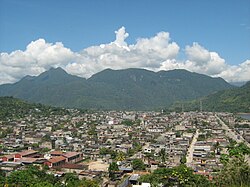
José Crespo y Castillo District is one of six districts of the province Leoncio Prado in Peru.[1]
José Crespo y Castillo | |
|---|---|
 View of Sumaq Puñuq (La Bella Durmiente), a limestone mountain range in the shape of a sleeping woman in Tingo María National Park, José Crespo y Castillo District | |
| Country | |
| Region | Huánuco |
| Province | Leoncio Prado |
| Founded | December 26, 1963 |
| Capital | Aucayacu |
| Area | |
| • Total | 2,829.67 km2 (1,092.54 sq mi) |
| Elevation | 540 m (1,770 ft) |
| Population | |
| • Total | 30,007 |
| • Density | 11/km2 (27/sq mi) |
| Time zone | UTC-5 (PET) |
| UBIGEO | 100604 |
Climate
| Climate data for Aucayacu, Jose Crespo Y Castillo, elevation 586 m (1,923 ft), (1991–2020) | |||||||||||||
|---|---|---|---|---|---|---|---|---|---|---|---|---|---|
| Month | Jan | Feb | Mar | Apr | May | Jun | Jul | Aug | Sep | Oct | Nov | Dec | Year |
| Mean daily maximum °C (°F) | 29.6 (85.3) | 29.4 (84.9) | 29.6 (85.3) | 30.3 (86.5) | 30.3 (86.5) | 30.0 (86.0) | 30.1 (86.2) | 30.8 (87.4) | 31.0 (87.8) | 30.6 (87.1) | 30.6 (87.1) | 30.0 (86.0) | 30.2 (86.3) |
| Mean daily minimum °C (°F) | 21.1 (70.0) | 21.1 (70.0) | 21.2 (70.2) | 21.0 (69.8) | 20.7 (69.3) | 20.2 (68.4) | 19.4 (66.9) | 19.5 (67.1) | 19.9 (67.8) | 20.3 (68.5) | 21.1 (70.0) | 21.1 (70.0) | 20.6 (69.0) |
| Average precipitation mm (inches) | 429.4 (16.91) | 390.2 (15.36) | 383.5 (15.10) | 263.0 (10.35) | 217.1 (8.55) | 212.7 (8.37) | 153.7 (6.05) | 127.6 (5.02) | 163.6 (6.44) | 285.5 (11.24) | 333.6 (13.13) | 451.6 (17.78) | 3,411.5 (134.3) |
| Source: National Meteorology and Hydrology Service of Peru[2] | |||||||||||||
| Climate data for Tulumayo, Jose Crespo Y Castillo, elevation 612 m (2,008 ft), (1991–2020) | |||||||||||||
|---|---|---|---|---|---|---|---|---|---|---|---|---|---|
| Month | Jan | Feb | Mar | Apr | May | Jun | Jul | Aug | Sep | Oct | Nov | Dec | Year |
| Mean daily maximum °C (°F) | 30.1 (86.2) | 29.7 (85.5) | 30.1 (86.2) | 30.6 (87.1) | 30.4 (86.7) | 30.0 (86.0) | 30.1 (86.2) | 31.1 (88.0) | 31.6 (88.9) | 31.5 (88.7) | 31.3 (88.3) | 30.4 (86.7) | 30.6 (87.0) |
| Mean daily minimum °C (°F) | 20.9 (69.6) | 20.8 (69.4) | 20.7 (69.3) | 20.6 (69.1) | 20.5 (68.9) | 19.7 (67.5) | 19.0 (66.2) | 19.0 (66.2) | 19.5 (67.1) | 20.2 (68.4) | 20.8 (69.4) | 20.9 (69.6) | 20.2 (68.4) |
| Average precipitation mm (inches) | 292.4 (11.51) | 285.0 (11.22) | 251.7 (9.91) | 170.3 (6.70) | 140.4 (5.53) | 117.9 (4.64) | 96.3 (3.79) | 74.0 (2.91) | 100.4 (3.95) | 169.0 (6.65) | 236.1 (9.30) | 282.7 (11.13) | 2,216.2 (87.24) |
| Source: National Meteorology and Hydrology Service of Peru[2] | |||||||||||||