Size of this preview: 521 × 599 pixels. Other resolutions: 209 × 240 pixels | 417 × 480 pixels | 766 × 881 pixels.
Original file (766 × 881 pixels, file size: 1.39 MB, MIME type: image/png)
Summary
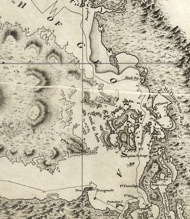
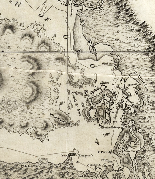
| Description | Excerpt of a map by George Vancouver, titled "A chart shewing part of the coast of N.W. America : with the tracks of His Majesty's sloop Discovery and armed tender Chatham / commanded by George Vancouver, Esqr. and prepared under his immediate inspection by Lieut. Joseph Baker..."; published 1798 |
| Date | |
| Source | http://hdl.loc.gov/loc.gmd/g3512c.ct000914 |
| Author | George Vancouver; digital version, Library of Congress, Geography and Map Division. |
| Permission (Reusing this file) | "The Library of Congress is providing access to these materials for educational and research purposes and is not aware of any U.S. copyright protection" (source: [1]) |
Licensing
This work is in the public domain in the United States because it is a work prepared by an officer or employee of the United States Government as part of that person’s official duties under the terms of Title 17, Chapter 1, Section 105 of the US Code.Note: This only applies to original works of the Federal Government and not to the work of any individual U.S. state, territory, commonwealth, county, municipality, or any other subdivision. This template also does not apply to postage stamp designs published by the United States Postal Service since 1978. (See § 313.6(C)(1) of Compendium of U.S. Copyright Office Practices). It also does not apply to certain US coins; see The US Mint Terms of Use. |  | |
| This file has been identified as being free of known restrictions under copyright law, including all related and neighboring rights. | ||
 | This map is available from the United States Library of Congress's Geography & Map Division under the digital ID ct000914 g3512c ct000914. This tag does not indicate the copyright status of the attached work. A normal copyright tag is still required. See Commons:Licensing. |
File history
Click on a date/time to view the file as it appeared at that time.
| Date/Time | Thumbnail | Dimensions | User | Comment | |
|---|---|---|---|---|---|
| current | 06:42, 16 May 2008 | | 766 × 881 (1.39 MB) | Pfly | {{Information |Description=Excerpt of a map by George Vancouver, titled "A chart shewing part of the coast of N.W. America : with the tracks of His Majesty's sloop Discovery and armed tender Chatham / commanded by George Vancouver, Esqr. and prepared unde |
File usage
The following pages on the English Wikipedia use this file (pages on other projects are not listed):
Global file usage
The following other wikis use this file:
- Usage on he.wikipedia.org
- Usage on hy.wikipedia.org
- Usage on ja.wikipedia.org
- Usage on no.wikipedia.org
- Usage on ro.wikipedia.org
- Usage on ru.wikipedia.org
- Usage on th.wikipedia.org
- Usage on uk.wikipedia.org
🔥 Top keywords: Main PageSpecial:SearchPage 3Wikipedia:Featured picturesHouse of the DragonUEFA Euro 2024Bryson DeChambeauJuneteenthInside Out 2Eid al-AdhaCleopatraDeaths in 2024Merrily We Roll Along (musical)Jonathan GroffJude Bellingham.xxx77th Tony AwardsBridgertonGary PlauchéKylian MbappéDaniel RadcliffeUEFA European Championship2024 ICC Men's T20 World CupUnit 731The Boys (TV series)Rory McIlroyN'Golo KantéUEFA Euro 2020YouTubeRomelu LukakuOpinion polling for the 2024 United Kingdom general electionThe Boys season 4Romania national football teamNicola CoughlanStereophonic (play)Gene WilderErin DarkeAntoine GriezmannProject 2025