No higher resolution available.
NESIS_description_NCDC.jpg (660 × 578 pixels, file size: 59 KB, MIME type: image/jpeg)
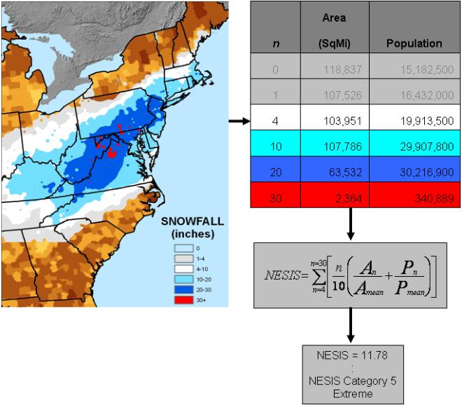
| Description | English: Screenshot of a series of charts used to describe the Northeast Snowfall Impact Scale. | |||
| Date | Unknown date | |||
| Source | http://www.ncdc.noaa.gov/snow-and-ice/nesis.php | |||
| Author | National Climatic Data Center | |||
| Permission (Reusing this file) |
|
File history
Click on a date/time to view the file as it appeared at that time.
| Date/Time | Thumbnail | Dimensions | User | Comment | |
|---|---|---|---|---|---|
| current | 17:45, 2 March 2010 | | 660 × 578 (59 KB) | Juliancolton | {{Information |Description={{en|1=Screenshot of a series of charts used to describe the {{w|Northeast Snowfall Impact Scale}}. }} |Source=http://www.ncdc.noaa.gov/snow-and-ice/nesis.php |Author=National Climatic Data Center |Date=Unknown |Permission={{PD- |
File usage
The following pages on the English Wikipedia use this file (pages on other projects are not listed):
Global file usage
The following other wikis use this file:
- Usage on de.wikipedia.org
Metadata
🔥 Top keywords: Main PageSpecial:SearchPage 3Wikipedia:Featured picturesHouse of the DragonUEFA Euro 2024Bryson DeChambeauJuneteenthInside Out 2Eid al-AdhaCleopatraDeaths in 2024Merrily We Roll Along (musical)Jonathan GroffJude Bellingham.xxx77th Tony AwardsBridgertonGary PlauchéKylian MbappéDaniel RadcliffeUEFA European Championship2024 ICC Men's T20 World CupUnit 731The Boys (TV series)Rory McIlroyN'Golo KantéUEFA Euro 2020YouTubeRomelu LukakuOpinion polling for the 2024 United Kingdom general electionThe Boys season 4Romania national football teamNicola CoughlanStereophonic (play)Gene WilderErin DarkeAntoine GriezmannProject 2025