.jpg)
.jpg&action=edit&redlink=1)
Size of this preview: 800 × 556 pixels. Other resolutions: 320 × 222 pixels | 640 × 445 pixels | 1,024 × 711 pixels | 1,280 × 889 pixels | 2,560 × 1,778 pixels | 3,523 × 2,447 pixels.
Original file (3,523 × 2,447 pixels, file size: 440 KB, MIME type: image/jpeg)
 | File:Map Victoria Aboriginal tribes.svg is a vector version of this file. It should be used in place of this JPG file when not inferior. File:Map Victoria Aboriginal tribes (colourmap).jpg → File:Map Victoria Aboriginal tribes.svg For more information, see Help:SVG. |  |
Summary
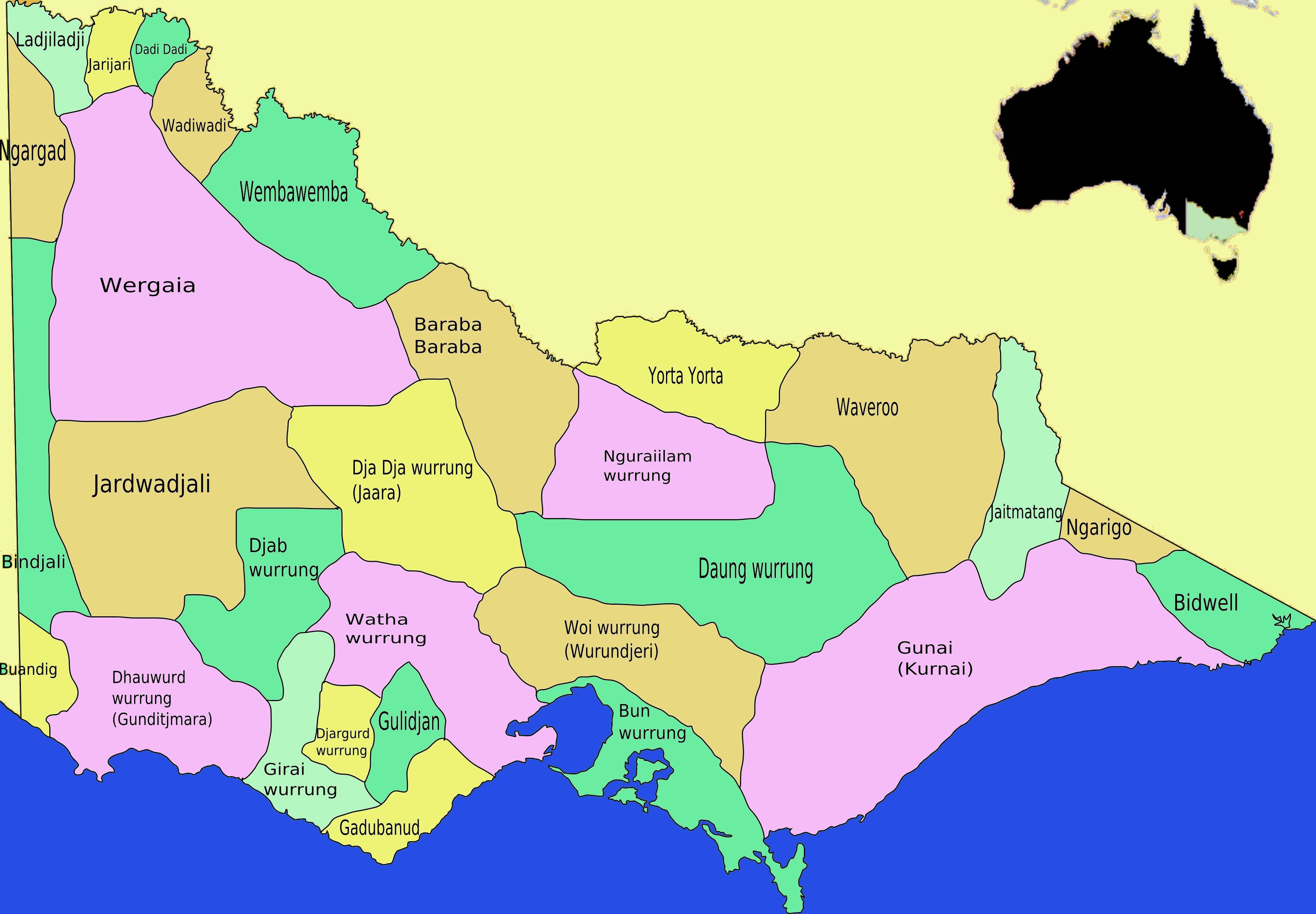
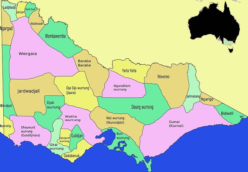
| Description | English: This is a map I created of aboriginal tribal territories and languages in Victoria, Australia coloured to easily distinguish different tribal areas derived from Image:Map Victoria Aboriginal tribes.svg which was also drawn by myself. The drawing is based on information and a map drawing in Ian D. Clark, Scars on the Landscape. A Register of Massacre sites in Western Victoria 1803-1859, Aboriginal Studies Press, 1995 ISBN 0855752815. To a lesser degree information was correlated with the Aboriginal Australian Map published by AIATSIS, especially for border areas and east Victoria.[1]. - Takver |
| Date | |
| Source | Own work |
| Author | Tirin aka Takver |
| Other versions | |
Licensing
I, the copyright holder of this work, hereby publish it under the following licenses:
This file is licensed under the Creative Commons Attribution-Share Alike 3.0 Unported license.
- You are free:
- to share – to copy, distribute and transmit the work
- to remix – to adapt the work
- Under the following conditions:
- attribution – You must give appropriate credit, provide a link to the license, and indicate if changes were made. You may do so in any reasonable manner, but not in any way that suggests the licensor endorses you or your use.
- share alike – If you remix, transform, or build upon the material, you must distribute your contributions under the same or compatible license as the original.
 | Permission is granted to copy, distribute and/or modify this document under the terms of the GNU Free Documentation License, Version 1.2 or any later version published by the Free Software Foundation; with no Invariant Sections, no Front-Cover Texts, and no Back-Cover Texts. A copy of the license is included in the section entitled GNU Free Documentation License. |
You may select the license of your choice.
File history
Click on a date/time to view the file as it appeared at that time.
| Date/Time | Thumbnail | Dimensions | User | Comment | |
|---|---|---|---|---|---|
| current | 12:38, 21 December 2008 | | 3,523 × 2,447 (440 KB) | Tirin | {{Information |Description={{en|1=This is a map I created of aboriginal tribal territories and languages in Victoria, Australia coloured to easily distinguish different tribal areas derived from Image:ap Victoria Aboriginal tribes.svg which was also |
File usage
The following pages on the English Wikipedia use this file (pages on other projects are not listed):
Global file usage
The following other wikis use this file:
- Usage on de.wikipedia.org
- Usage on en.wikiversity.org
- Usage on fr.wikipedia.org
- Usage on gl.wikipedia.org
- Usage on ms.wikipedia.org
- Usage on ru.wikipedia.org
- Usage on simple.wikipedia.org
- Usage on tr.wikipedia.org
Metadata
🔥 Top keywords: Main PageSpecial:SearchPage 3Wikipedia:Featured picturesHouse of the DragonUEFA Euro 2024Bryson DeChambeauJuneteenthInside Out 2Eid al-AdhaCleopatraDeaths in 2024Merrily We Roll Along (musical)Jonathan GroffJude Bellingham.xxx77th Tony AwardsBridgertonGary PlauchéKylian MbappéDaniel RadcliffeUEFA European Championship2024 ICC Men's T20 World CupUnit 731The Boys (TV series)Rory McIlroyN'Golo KantéUEFA Euro 2020YouTubeRomelu LukakuOpinion polling for the 2024 United Kingdom general electionThe Boys season 4Romania national football teamNicola CoughlanStereophonic (play)Gene WilderErin DarkeAntoine GriezmannProject 2025