

Original file (1,250 × 695 pixels, file size: 141 KB, MIME type: image/png)
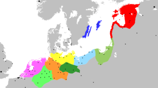
| DescriptionExtent of the Hansa.png | Map of the Hanseatic League, circa 1400, showing Circles, Kontore and principal Hanseatic cities | |||
| Date | (UTC) | |||
| Source | Adapted from Image:Extent of the Hansa.jpg, itself in the public domain because its first publication occurred in 1902 — prior to January 1, 1923 | |||
| Author | OwenBlacker | |||
| Permission (Reusing this file) |
| |||
| Other versions | Image:Extent of the Hansa.jpg |
Click on a date/time to view the file as it appeared at that time.
| Date/Time | Thumbnail | Dimensions | User | Comment | |
|---|---|---|---|---|---|
| current | 00:12, 20 November 2007 | | 1,250 × 695 (141 KB) | OwenBlacker | {{Information |Description= Map of the Hanseatic League, circa 1400, showing Circles, ''Kontore'' and principal Hanseatic cities |Source= Adapted from Image:Extent of the Hansa.jpg |Date=~~~~~ |Author=~~~ |Permission={{PD-self}} |other_versio |
The following other wikis use this file:
View more global usage of this file.