Size of this preview: 644 × 599 pixels. Other resolutions: 258 × 240 pixels | 516 × 480 pixels | 677 × 630 pixels.
Original file (677 × 630 pixels, file size: 59 KB, MIME type: image/png)
zayan
Summary
 | File:Iberia 300BC-en.svg is a vector version of this file. It should be used in place of this PNG file when not inferior. File:Ethnographic Iberia 200 BCE.PNG → File:Iberia 300BC-en.svg For more information, see Help:SVG. |  |
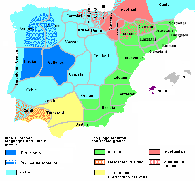
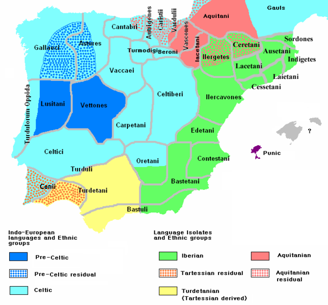
| Description | English: Ethnographic and Linguistic Map of the Iberian Peninsula at about 200 BCE (at the end of the Second Punic War). Based on the map done by Portuguese Archeologist Luís Fraga (luisfraga@arqueotavira.com), from the "Campo Arqueológico de Tavira" (Tavira Archeological Camp - official site), in Tavira, Algarve - Portugal. The reference map can be found at this location, and a pdf version, with extensive and detailed information on the criteria used, as well as the long bibliography used to source the map can be found here. |
| Date | |
| Source | self-made from Image:Blank-peninsula Iberica.png |
| Author | The Ogre |
| Other versions | Italian version |
Licensing
I, the copyright holder of this work, hereby publish it under the following licenses:
 | Permission is granted to copy, distribute and/or modify this document under the terms of the GNU Free Documentation License, Version 1.2 or any later version published by the Free Software Foundation; with no Invariant Sections, no Front-Cover Texts, and no Back-Cover Texts. A copy of the license is included in the section entitled GNU Free Documentation License. |
This file is licensed under the Creative Commons Attribution-Share Alike Attribution-Share Alike 4.0 International, 3.0 Unported, 2.5 Generic, 2.0 Generic and 1.0 Generic license.
- You are free:
- to share – to copy, distribute and transmit the work
- to remix – to adapt the work
- Under the following conditions:
- attribution – You must give appropriate credit, provide a link to the license, and indicate if changes were made. You may do so in any reasonable manner, but not in any way that suggests the licensor endorses you or your use.
- share alike – If you remix, transform, or build upon the material, you must distribute your contributions under the same or compatible license as the original.
You may select the license of your choice.
File history
Click on a date/time to view the file as it appeared at that time.
| Date/Time | Thumbnail | Dimensions | User | Comment | |
|---|---|---|---|---|---|
| current | 10:25, 14 May 2011 | | 677 × 630 (59 KB) | Jafeluv | Reverted to version as of 09:21, 25 April 2011 |
| 21:49, 13 May 2011 |  | 677 × 630 (53 KB) | Ilario111 | Reverted to version as of 18:41, 22 April 2011 | |
| 09:21, 25 April 2011 |  | 677 × 630 (59 KB) | The Ogre | RV THE SAME OLD VANDAL Reverted to version as of 20:21, 13 April 2011 | |
| 18:41, 22 April 2011 |  | 677 × 630 (53 KB) | Madrid747 | Reverted to version as of 19:58, 13 April 2011 | |
| 20:21, 13 April 2011 |  | 677 × 630 (59 KB) | Jafeluv | Reverted to version as of 12:01, 9 April 2011 | |
| 19:58, 13 April 2011 |  | 677 × 630 (53 KB) | Windsurf101 | colors | |
| 12:01, 9 April 2011 |  | 677 × 630 (59 KB) | The Ogre | RV VANDAL - Reverted to version as of 18:34, 16 September 2008 | |
| 21:35, 8 April 2011 |  | 677 × 630 (53 KB) | Dumdum~commonswiki | More accurate | |
| 18:34, 16 September 2008 |  | 677 × 630 (59 KB) | Tautintanes | The Indigetes, Laietani, Cessetani and Ausetani minted their own coins with his name. They can’t be forgotten in a map like this. | |
| 07:11, 9 March 2008 |  | 677 × 630 (44 KB) | The Ogre | Still another correction for the Baleares |
File usage
The following pages on the English Wikipedia use this file (pages on other projects are not listed):
- Aquitanian language
- Celtiberians
- Celtic nations
- Celtici
- Contestani
- Cynetes
- Hispania
- History of Spain
- Ilercavones
- List of Celtic place names in Portugal
- List of revolutions and rebellions
- Lusitanians
- Portuguese people
- Talk:Celts/Archive 7
- User:Falcaorib/Ancient Empires (300 BC-01 AD)
- User:Sasha l~enwiki/DNA/R
- User:The Ogre/Images
Global file usage
The following other wikis use this file:
- Usage on af.wikipedia.org
- Usage on ar.wikipedia.org
- Usage on arz.wikipedia.org
- Usage on ast.wikipedia.org
- Usage on ba.wikipedia.org
- Usage on bg.wikipedia.org
- Usage on br.wikipedia.org
- Usage on ca.wikipedia.org
- Usage on cy.wikipedia.org
- Usage on de.wikipedia.org
- Usage on el.wikipedia.org
- Usage on en.wiktionary.org
- Usage on eo.wikipedia.org
- Usage on es.wikipedia.org
- Usage on eu.wikipedia.org
- Usage on fa.wikipedia.org
- Usage on fi.wikipedia.org
- Usage on fi.wikibooks.org
- Usage on fr.wikipedia.org
View more global usage of this file.
🔥 Top keywords: Main PageSpecial:SearchPage 3Wikipedia:Featured picturesHouse of the DragonUEFA Euro 2024Bryson DeChambeauJuneteenthInside Out 2Eid al-AdhaCleopatraDeaths in 2024Merrily We Roll Along (musical)Jonathan GroffJude Bellingham.xxx77th Tony AwardsBridgertonGary PlauchéKylian MbappéDaniel RadcliffeUEFA European Championship2024 ICC Men's T20 World CupUnit 731The Boys (TV series)Rory McIlroyN'Golo KantéUEFA Euro 2020YouTubeRomelu LukakuOpinion polling for the 2024 United Kingdom general electionThe Boys season 4Romania national football teamNicola CoughlanStereophonic (play)Gene WilderErin DarkeAntoine GriezmannProject 2025