
Size of this preview: 800 × 598 pixels. Other resolutions: 320 × 239 pixels | 640 × 478 pixels | 1,024 × 765 pixels | 1,345 × 1,005 pixels.
Original file (1,345 × 1,005 pixels, file size: 99 KB, MIME type: image/png)
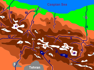
| Map of central Alborz | Peaks: | 1 Alam Kūh |
|---|---|---|
 -25m to 500m 500m to 1500m 1500m to 2500m 2500 to 3500m 3500m to 4500m 4500m to 5610m | 2 Azad Kooh | 3 Damāvand |
| 4 Berar | 5 Khaharan | |
| 6 Ghal`eh Gardan | 7 Gorg | |
| 8 [1] | 9 [2] | |
| 10 Mīšīneh Marg | 11 Naz | |
| 12 [3] | 13 Sīālān | |
| 14 [4] | 15 Varavašt | |
| Rivers: | 0 | |
| 1 Alamūt | 2 Chālūs | |
| 3 Do Hezār | 4 Harāz | |
| 5 Jājrūd | 6 Karaj | |
| 7 Kojūr | 8 Lār | |
| 9 Nūr | 10 Sardāb | |
| 11 Seh Hazār | 12 Shāh Rūd | |
| Cities: | 1 Āmol | |
| 2 Chālūs | 3 [5] | |
| Other: | D Dīzīn | |
| E Emāmzādeh Hāšem | K Kandovān Tunnel | |
| * Latīān Dam | ** Lār Dam |
| Description | English: Alborz mountain range in northern Iran. Dansk: Alborz-bjergkæden i det nordlige Iran. | ||
| Date | |||
| Source | Map by Michèle Chevalier | ||
| Author | Uploaded to English Wikipedia by Siamax as AlborzCentralColoredNumbered.PNG | ||
| Permission (Reusing this file) |
|
| Annotations | This image is annotated: View the annotations at Commons |
File history
Click on a date/time to view the file as it appeared at that time.
| Date/Time | Thumbnail | Dimensions | User | Comment | |
|---|---|---|---|---|---|
| current | 16:57, 15 April 2007 | | 1,345 × 1,005 (99 KB) | EPO | {{Information |Description={{en|Alborz mountain range in northern Iran.}} {{da|Alborz-bjergkæden i det nordlige Iran}} |Source=[http://chevalier.michele.free.fr/iran/photos_iran/map_alborz.jpg Map by Michèle Chevalier] |Date=2006 |Author=Uploaded to [[ |
File usage
The following pages on the English Wikipedia use this file (pages on other projects are not listed):
- Alam-Kuh
- Alamut River
- Alborz
- Chalus River
- Cheshmeh Kileh River
- Do Hezar River
- Haraz River
- Jajrud (river)
- Kojoor River
- Lar National Park
- Lar River
- Latyan Dam
- Mount Damavand
- Noor River
- Polur, Iran
- Road 77 (Iran)
- Road 79 (Iran)
- Sardab River
- Se Hezar River
- Shah Alborz
- Shahrud (river)
- Sialan
- Tochal
- User:Siamax
- Template:Central Alborz
Global file usage
The following other wikis use this file:
- Usage on af.wikipedia.org
- Usage on ar.wikipedia.org
- Usage on arz.wikipedia.org
- Usage on bg.wikipedia.org
- Usage on ca.wikipedia.org
- Usage on da.wikipedia.org
- Usage on de.wikipedia.org
- Usage on el.wikipedia.org
- Usage on eo.wikipedia.org
- Usage on es.wikipedia.org
- Usage on eu.wikipedia.org
- Usage on fa.wikipedia.org
- Usage on fr.wikipedia.org
- Usage on gl.wikipedia.org
- Usage on he.wikipedia.org
- Usage on hr.wikipedia.org
- Usage on hu.wikipedia.org
- Usage on ja.wikipedia.org
- Usage on lt.wikipedia.org
- Usage on ml.wikipedia.org
- Usage on ro.wikipedia.org
- Usage on ru.wikipedia.org
- Usage on sh.wikipedia.org
- Usage on tg.wikipedia.org
- Usage on uk.wikipedia.org
- Usage on vi.wikipedia.org
- Usage on www.wikidata.org
- Usage on zh.wikipedia.org
🔥 Top keywords: Main PageSpecial:SearchPage 3Wikipedia:Featured picturesHouse of the DragonUEFA Euro 2024Bryson DeChambeauJuneteenthInside Out 2Eid al-AdhaCleopatraDeaths in 2024Merrily We Roll Along (musical)Jonathan GroffJude Bellingham.xxx77th Tony AwardsBridgertonGary PlauchéKylian MbappéDaniel RadcliffeUEFA European Championship2024 ICC Men's T20 World CupUnit 731The Boys (TV series)Rory McIlroyN'Golo KantéUEFA Euro 2020YouTubeRomelu LukakuOpinion polling for the 2024 United Kingdom general electionThe Boys season 4Romania national football teamNicola CoughlanStereophonic (play)Gene WilderErin DarkeAntoine GriezmannProject 2025