The exclusive economic zone of the Philippines (Philippine EEZ), per the mandate of the United Nations Convention on the Law of the Sea (UNCLOS), consists of four subzones.[1]It covers 2,263,816 square kilometers (874,064 sq mi) of sea. The Philippines has 7,641 islands comprising the Philippine archipelago.[2] The zone's coordinates are between 116° 40', and 126° 34' E longitude and 4° 40' and 21° 10' N latitude. It is bordered by the Philippine Sea[3] to the east and north, the South China Sea[4] to the west, and the Celebes Sea[5] to the south.

Disputes

The Philippines has territorial disputes in the South China Sea, mainly with the People's Republic of China. Nearly the whole South China Sea is claimed by China with its nine-dash line. This contested line cuts half of the Philippines' EEZ. In 2011, President Benigno Aquino III stated that "China's nine-dash line territorial claim over the entire South China Sea is against international laws, particularly the United Nations Convention on the Law of the Sea (UNCLOS)".[6] In 2013, China began building artificial islands and military bases on reefs in the Spratly Islands and on Scarborough Shoal, which it seized in 2012. As of 2019[update], China controls 20 outposts in the Paracel Islands and 7 in the Spratlys.[7]
In July 2016, the Arbitral Tribunal set up under Annex VII of the United Nations Convention on the Law of the Sea in the Hague ruled against China's nine-dash line demarcation. As the Council on Foreign Relations wrote at the time, "The panel found that China’s claims of historic rights within the nine-dash line, which Beijing uses to demarcate its claims in the South China Sea, were without legal foundation. The panel also concluded that Beijing’s activities within the Philippines’ two-hundred-nautical-mile exclusive economic zone (EEZ), such as illegal fishing and environmentally ruinous artificial island construction, infringed on Manila’s sovereign rights."
On June 12, 2019, a Chinese vessel collided with and sank an anchored Philippine fishing boat (F/B Gem-Ver 1) near Recto Bank in the South China Sea. The Chinese vessel did not save the 22 Filipino fishermen on-board according to the Philippine Department of National Defense. A couple of minutes later, they were rescued by a Vietnamese fishing boat. The Armed Forces of the Philippines said the collision was "far from accidental."[8]
On April 15, 2021, the National Task Force for the West Philippine Sea (NTF-WPS) reported that approximately 240,000 kilos (260 tons) of fish have been illegally taken by Chinese fishing vessels in the South China Sea every day. The Chinese fishing vessels illegally operate around the Union Banks and Thitu Island (Pag-asa Islands).[9] The overfishing causes the depletion of marine resources.[9] During the same month, an estimated 240 Chinese vessels were patrolling throughout the South China Sea.[9]
In November 2021, two Filipino military supply boats were blocked by three Chinese coast guard ships which also fired water cannons.[10] The supply vessels were headed to Second Thomas Shoal within the exclusive economic zone of the Philippines.[10] The atoll has been occupied by a Philippine military contingent since 1999. The incident was strongly condemned by Philippine Foreign Secretary Teodoro Locsin and former Philippine President Rodrigo Duterte.[10][11]
Maps
![The exclusive economic zone of the Philippines shown in blue lines,[12] eleven dash-line claim by China shown in red lines, treaty line of the Treaty of Paris (1898) shown in green line.](//upload.wikimedia.org/wikipedia/en/thumb/5/59/Ph_EEZ_Map.png/160px-Ph_EEZ_Map.png) The exclusive economic zone of the Philippines shown in blue lines,[12] eleven dash-line claim by China shown in red lines, treaty line of the Treaty of Paris (1898) shown in green line.
The exclusive economic zone of the Philippines shown in blue lines,[12] eleven dash-line claim by China shown in red lines, treaty line of the Treaty of Paris (1898) shown in green line.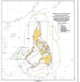 Map prepared by the NAMRIA, with the green line showing the maximum extent of the EEZ (ignoring landmass of neighboring countries) and the theoretical EEZ based on median line in purple.
![The exclusive economic zone of the Philippines shown in blue lines,[12] eleven dash-line claim by China shown in red lines, treaty line of the Treaty of Paris (1898) shown in green line.](https://www.search.com.vn/wiki/en/File:Ph_EEZ_Map.png)
