List of Colorado Scenic and Historic Byways
Colorado Scenic and Historic Byways[1][2][3] are highway and backroad routes in the U.S. state of Colorado designated by the Colorado Scenic and Historic Byways Commission[4] for their scenic and historic values. These byways follow existing roads or highways and are signed with a Colorado blue columbine (the Colorado state flower) logo denoting the route. The Colorado Scenic and Historic Byways Program was established in March 1989, and is one of the oldest state scenic byway programs. Since 1989, the program has designated 26 Colorado Scenic and Historic Byways with 2,585 miles (4,160 km) of roadway, 4,459 miles (7,176 km) including scenic byway extensions in adjacent states.
| Colorado Scenic and Historic Byways | |
|---|---|
 Colorado Scenic and Historic Byway route sign | |
 | |
| Highway names | |
| Interstates | Interstate nn (I-nn) |
| US Highways | U.S. Highway nn (US nn) |
| State | State Highway nn (SH nn) |
| County | County Road nn (CR nn) |
| Forest | Forest Road nnn (FR nnn) |
| System links | |
| |
In addition to state scenic byway designations, four federal agencies designate specific types of scenic byways:
- The Federal Highway Administration designates National Scenic Byways and All-American Roads (the highest designation.)
- The National Park Service administers congressionally authorized National Parkways.
- The United States Forest Service designates and manages National Forest Scenic Byways in National Forests and National Grasslands.
- The Bureau of Land Management designates and manages Back Country Byways in areas managed by the BLM.
The Colorado Scenic and Historic Byways Commission works closely with these four federal agencies to select scenic and historic byways that meet federal criteria. Of the 26 current Colorado designated byways, 21 already have a federal designation as well. These include two All-American Roads,[5] 11 National Scenic Byways,[5] ten National Forest Scenic Byways,[6] and three Back Country Byways.[7]
The 13 combined All-American Roads and National Scenic Byways in Colorado are currently the most of any state. Five Colorado byways currently have two federal designations. The San Juan Skyway Scenic and Historic Byway is both an All-American Road and a National Forest Scenic Byway. The Grand Mesa National Scenic Byway, the Highway of Legends National Scenic Byway, and the Silver Thread Scenic and Historic Byway are both National Scenic Byways and National Forest Scenic Byways. The Gold Belt Tour Scenic and Historic Byway is both a National Scenic Byway and a Back Country Byway.
Colorado Scenic and Historic Byways Commission
The Colorado Scenic and Historic Byways Commission[8] was established in 1989 to administer the Colorado Scenic and Historic Byways Program. The Governor of Colorado appoints the members of the commission.[9]
The program is a statewide partnership intended to provide recreational, educational, and economic benefits to residents and visitors by designating, interpreting, protecting, and promoting a system of outstanding touring routes in Colorado.
Proposed routes are nominated by local communities and approved by the Commission, but byway development is managed at the local level.
The Commission works with:
- State agencies including the Colorado Department of Transportation, the Colorado Department of Natural Resources, the Colorado Department of Local Affairs, and the Colorado Tourism Office;
- Federal agencies including the National Park Service, the United States Forest Service, the Bureau of Land Management, and the Federal Highway Administration;
- County and municipal governments;
- Local byways organizations, community organizations, interested individuals, and public and private resources;
- Scenic byway programs in the seven adjacent states of Wyoming, Nebraska, Kansas, Oklahoma, New Mexico, Arizona, and Utah.
The Commission uses the following criteria to select potential byways:
- The proposed Scenic and Historic Byway must possess unusual, exceptional, and distinctive scenic, recreational, historical, educational, scientific, geological, natural, wildlife, cultural, or ethnic features.
- The proposed Scenic and Historic Byway must be suitable for the prescribed types of vehicular use.
- The proposed Scenic and Historic Byway must be an existing route and have legal public access.
- The proposed Scenic and Historic Byway must have strong local support and proponents must demonstrate coordination with relevant agencies.
- The proposed Scenic and Historic Byway must be accompanied by a conceptual plan, as specified in the nomination process.
The Commission favors proposed byways with both scenic and historic features. Byways with predominantly scenic features are labeled a "Scenic Byway" or a "National Scenic Byway" if also an All-American Road or a National Scenic Byway. Byways with predominantly historic features are labeled a "Historic Byway". Byways with both strong scenic and historic features are labeled a "Scenic and Historic Byway".
List
| Name | Length [a] | Southern or western terminus | Northern or eastern terminus | Date | Description | Ref |
|---|---|---|---|---|---|---|
| Alpine Loop Back Country Byway | 63 miles 101 km | Loop from Ouray to Engineer Pass,[b] Capitol City,[c] Lake City, Lake San Cristobal, Cinnamon Pass,[d] and back to Ouray, or on to Animas Forks and Silverton[e] | 1989 | This byway traverses the rugged San Juan Mountains of southwestern Colorado; also a Back Country Byway.[f][g] | [10][11][12] | |
| Cache la Poudre-North Park Scenic Byway | 101 miles 163 km | Walden | Fort Collins | 1991 | This byway explores Poudre Canyon, Cameron Pass,[h] and North Park in north-central Colorado; also a National Forest Scenic Byway | [13][14][15] |
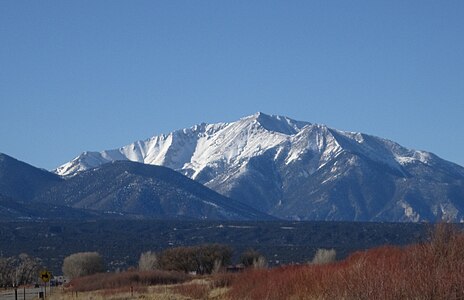
| Collegiate Peaks Scenic Byway | 57 miles 92 km | Poncha Springs or Salida | SH 82 north of Granite | 2015 | This byway follows the Arkansas River past the majestic Collegiate Peaks in central Colorado. | [16][17][18] |
| Colorado River Headwaters Scenic Byway | 80 miles 129 km | State Bridge | Grand Lake | 2008 | This byway follows the headwaters of the Colorado River in north-central Colorado; also a National Scenic Byway.[i] | [19][20][21] |
| Dinosaur Diamond Scenic and Historic Byway | 134 miles 216 km[j] | Loop from Grand Junction to Colorado NM, Fruita, Douglas Pass, Rangely, Dinosaur, Dinosaur NM, Vernal, Duchesne, Price, Green River, Arches NP, Moab, and back to Grand Junction | 1997 | This byway loops through the dinosaur fossil laden canyon country of northwestern Colorado and northeastern Utah; also a National Scenic Byway. | [22][23][24][25] | |
| Flat Tops Trail Scenic Byway | 82 miles 132 km | SH 13 in Meeker | SH 131 in Yampa | 1991 | This byway traverses the Flat Tops range of northwestern Colorado; also a National Forest Scenic Byway.[g][i] | [26][27][28] |
| Frontier Pathways Scenic Byway | 103 miles 166 km | Westcliffe | I-25 exit 98B in Pueblo or I-25 exit 74 | 1998 | This byway passes through the Wet Mountains region of south-central Colorado; also a National Scenic Byway.[k] | [29][30][31] |
| Gold Belt Tour Scenic and Historic Byway | 131 miles 211 km | Loop from Cañon City to Florence, Phantom Canyon, Victor, Cripple Creek,[l] Florissant Fossil Beds NM, Florissant, Royal Gorge, and back to Cañon City | 2000 | This byway explores the historic Gold Belt mining region of central Colorado; also a National Scenic Byway and a Back Country Byway.[i][m] | [32][33][34] | |
| Grand Mesa Scenic Byway | 63 miles 101 km | Cedaredge | I-70 exit 49 | 1991 | This byway crosses the Grand Mesa in western Colorado; also a National Scenic Byway and a National Forest Scenic Byway. | [35][36][37] |
| Guanella Pass Scenic Byway | 22 miles 35 km | US 285 near Grant | I-70 exit 232 in Georgetown | 1991 | This byway crosses the beautiful Front Range mountains of central Colorado; also a National Forest Scenic Byway.[g][i][n] | [38][39][40] |
| Highway of Legends Scenic Byway | 82 miles 132 km | I-25 exit 14 in Trinidad | Walsenburg or Aguilar | 2021 | This byway circles the historic Spanish Peaks of south-central Colorado; also a National Scenic Byway and a National Forest Scenic Byway.[g][i][o] | [41][42][43] |
| Lariat Loop Scenic and Historic Byway | 40 miles 64 km | Loop from Golden to Lookout Mountain Park, Genesee Park, Evergreen, Morrison, Red Rocks Park, Dinosaur Ridge, Mount Vernon, Dakota Cut, and back to Golden | 2002 | This byway explores the Front Range foothills west of Denver; also a National Scenic Byway.[p] | [44][45][46] | |
| Los Caminos Antiguos Scenic and Historic Byway | 129 miles 208 km | Cumbres Pass[q] | Alamosa | 2000 | This byway traverses the historic San Luis Valley to Great Sand Dunes National Park and Preserve in south-central Colorado ; also a Back Country Byway.[r] | [47][48][49] |
| Mount Evans Scenic Byway | 49 miles 79 km | I-70 exit 240 in Idaho Springs | SH 74 in Bergen Park | 1991 | This byway climbs to the 14,271-foot (4,350 m) summit of Mount Evans in central Colorado; also a National Forest Scenic Byway.[g][s] | [50][51][52] |
| Pawnee Pioneer Trails Scenic Byway | 128 miles 206 km | Ault | Sterling or Fort Morgan | 1992 | This byway explores the shortgrass prairie region of Pawnee National Grassland in northeastern Colorado.[i] | [53][54][55] |
| Peak to Peak Scenic Byway | 55 miles 89 km | Blackhawk[t] | Estes Park | 1989 | This byway crosses the Front Range foothills to Rocky Mountain National Park in north-central Colorado; also a National Forest Scenic Byway. | [56][57][58] |
| San Juan Skyway Scenic and Historic Byway | 236 miles 380 km | Loop from Durango to Coal Bank Pass,[u] Molas Pass,[v] Silverton, Red Mountain Pass,[w] Ouray, Ridgway, Dallas Divide, Telluride, Lizard Head Pass,[x] Rico, Dolores, Canyons of the Ancients NM, Cortez, Mesa Verde NP, Mancos, and back to Durango | 1989 | This byway loops through the spectacular San Juan Mountains to Canyons of the Ancients National Monument and Mesa Verde National Park in southwestern Colorado; also an All-American Road and National Forest Scenic Byway.[y] | [59][60][61] | |
| Santa Fe Trail Scenic and Historic Byway | 188 miles 303 km[z] | Santa Fe, New Mexico | US 50 east of Holly, Colorado | 1991 | This byway follows the Santa Fe National Historic Trail through southeastern Colorado and northern New Mexico; also a National Scenic Byway.[aa] | [62][63][64][65] |
| Silver Thread Scenic and Historic Byway | 117 miles 188 km | US 160 in South Fork | US 50 west of Gunnison | 1989 | This byway traverses the historic San Juan Mountains of southwestern Colorado; also a National Scenic Byway and National Forest Scenic Byway.[ab] | [66][67][68] |
| South Platte River Trail Scenic and Historic Byway | 19 miles 31 km | Loop from Julesburg to Ovid and back to Julesburg | 1991 | This byway explores the historic Pony Express region of northeastern Colorado. | [69][70][71] | |
| Top of the Rockies Scenic Byway | 115 miles 185 km | Aspen | I-70 exit 171 near Minturn or I-70 exit 195 at Copper Mountain | 1993 | This byway explores the highest region of the Rocky Mountains located in central Colorado; also a National Scenic Byway.[g][ac] | [72][73][74] |
| Tracks Across Borders Scenic and Historic Byway | 89 miles 143 km[ad] | Durango, Colorado | Dulce, New Mexico or Chimney Rock National Monument, Colorado | 2015 | This byway follows a historic narrow-gauge railroad route through the Ute and Apache lands of southwestern Colorado and northern New Mexico.[i] | [75][76][77] |
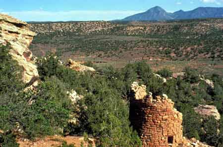
| Trail of the Ancients Scenic and Historic Byway | 116 miles 187 km[ae] | Loop from Cortez to Canyons of the Ancients NM, Lowry Pueblo,[af] Hovenweep NM, Bluff, Goosenecks, Mexican Hat, Monument Valley, Kayenta, Mexican Water, Four Corners Monument, Ute Mountain, Towaoc, Yucca House NM,[ag] and back to Cortez[ah] | 1994 | This byway loops through the historic Canyons of the Ancients National Monument and the Four Corners region of Colorado, Utah, Arizona, and New Mexico; also a National Scenic Byway.[i] | [78][79][80][81][82][83][84] | |
| Trail Ridge Road/Beaver Meadow Scenic Byway | 48 miles 77 km | Grand Lake | Estes Park | 1996 | This crosses the magnificent Rocky Mountain National Park in north-central Colorado; also an All-American Road.[g][ai] | [85][86][87] |
| Unaweep Tabeguache Scenic Byway | 133 miles 214 km | Placerville | Whitewater | 1990 | This byway explores the Colorado Plateau canyon country of western Colorado. | [88][89][90] |
| West Elk Loop Scenic and Historic Byway | 205 miles 330 km | Loop from Carbondale to Redstone, McClure Pass, Paonia, Hotchkiss, Gunnison, Crested Butte, Kebler Pass,[aj] and back to Carbondale | 1991 | This byway explores the historic West Elk Mountains of west-central Colorado; also a National Forest Scenic Byway.[g][i] | [91][92][93] | |
Gallery


 The Flat Tops Wilderness from the Flat Tops Trail Scenic Byway
 Bicycling on the Gold Belt Tour Scenic and Historic Byway
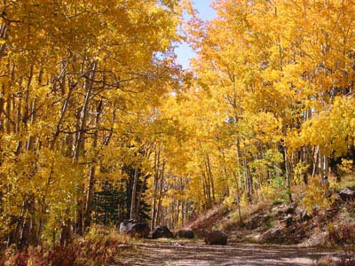 Autumn along the Grand Mesa Scenic Byway


 Echo Lake along the Mount Evans Scenic Byway
 The Indian Peaks Wilderness from the Peak to Peak Scenic Byway
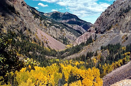


 Autumn along the West Elk Loop Scenic and Historic Byway
.jpg)
.jpg)


.jpg)


