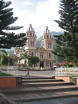
Cajamarca is a town and municipality in the Tolima Department of Colombia. The population of the municipality was 17,309 as of the 2018 census.[1] The municipality has two populated centres, the town centre of Cajamarca and the locality of Anaime. It is located along the Pan-American Highway.
Cajamarca, Tolima | |
|---|---|
Municipality and town | |
 | |
 Location of the municipality and town of Cajamarca, Tolima in the Tolima Department of Colombia. | |
| Country | |
| Department | Tolima Department |
| Government | |
| • Mayor | Julio Roberto Vargas Malagón |
| Area | |
| • Total | 520 km2 (200 sq mi) |
| Elevation | 1,814 m (5,951 ft) |
| Population (Census 2018[1]) | |
| • Total | 17,309 |
| • Density | 33/km2 (86/sq mi) |
| Time zone | UTC-5 (Colombia Standard Time) |
In 1886, colonisers from Antioquia colonised the area currently known as Anaime, and started to develop the land for agriculture. In 1913, the Bishop of Ibagué Ismael Perdomo bought the land of the municipality and officially founded the municipality of Cajamarca, which stands for 'cold land' in Quechua.[2]
The main economic activity is agriculture, and the town is also known as the 'agricultural larder' of Colombia.[3]
Internationally, the town is best known as the location of the La Colosa gold mining project of AngloGold Ashanti.
Climate
| Climate data for Cajamarca, elevation 1,920 m (6,300 ft), (1981–2010) | |||||||||||||
|---|---|---|---|---|---|---|---|---|---|---|---|---|---|
| Month | Jan | Feb | Mar | Apr | May | Jun | Jul | Aug | Sep | Oct | Nov | Dec | Year |
| Mean daily maximum °C (°F) | 24.2 (75.6) | 24.3 (75.7) | 24.0 (75.2) | 23.4 (74.1) | 23.2 (73.8) | 23.1 (73.6) | 23.2 (73.8) | 23.8 (74.8) | 23.8 (74.8) | 23.6 (74.5) | 23.5 (74.3) | 24.0 (75.2) | 23.7 (74.7) |
| Daily mean °C (°F) | 18.8 (65.8) | 19.0 (66.2) | 18.9 (66.0) | 18.8 (65.8) | 18.7 (65.7) | 18.7 (65.7) | 18.6 (65.5) | 19.0 (66.2) | 18.9 (66.0) | 18.6 (65.5) | 18.6 (65.5) | 18.7 (65.7) | 18.8 (65.8) |
| Mean daily minimum °C (°F) | 13.5 (56.3) | 13.8 (56.8) | 13.9 (57.0) | 14.2 (57.6) | 14.2 (57.6) | 14.0 (57.2) | 13.8 (56.8) | 13.9 (57.0) | 13.9 (57.0) | 13.9 (57.0) | 13.8 (56.8) | 13.6 (56.5) | 13.9 (57.0) |
| Average precipitation mm (inches) | 51.8 (2.04) | 66.9 (2.63) | 101.8 (4.01) | 150.2 (5.91) | 183.1 (7.21) | 135.4 (5.33) | 107.7 (4.24) | 91.3 (3.59) | 128.7 (5.07) | 124.2 (4.89) | 99.4 (3.91) | 73.5 (2.89) | 1,314.1 (51.74) |
| Average precipitation days | 13 | 13 | 16 | 21 | 22 | 17 | 15 | 14 | 17 | 20 | 18 | 15 | 199 |
| Average relative humidity (%) | 79 | 79 | 80 | 81 | 82 | 81 | 80 | 78 | 78 | 80 | 81 | 80 | 80 |
| Mean monthly sunshine hours | 161.2 | 138.3 | 136.4 | 114.0 | 124.0 | 123.0 | 136.4 | 133.3 | 129.0 | 130.2 | 129.0 | 148.8 | 1,603.6 |
| Mean daily sunshine hours | 5.2 | 4.9 | 4.4 | 3.8 | 4.0 | 4.1 | 4.4 | 4.3 | 4.3 | 4.2 | 4.3 | 4.8 | 4.4 |
| Source: Instituto de Hidrologia Meteorologia y Estudios Ambientales[4] | |||||||||||||
References
4°25′N 75°30′W / 4.417°N 75.500°W
