Boeschepe (French pronunciation: [bɔskɛp]) is a commune in the Nord department in northern France, next to the Belgian border.[3]
Boeschepe | |
|---|---|
 A general view of Boeschepe | |
_Nord-France.svg) Coat of arms | |
Location of Boeschepe  | |
 Boeschepe  Boeschepe | |
| Coordinates: 50°48′01″N 2°41′31″E / 50.8003°N 2.6919°E | |
| Country | France |
| Region | Hauts-de-France |
| Department | Nord |
| Arrondissement | Dunkerque |
| Canton | Bailleul |
| Intercommunality | CC Flandre Intérieure |
| Government | |
| • Mayor (2020–2026) | Luc Van Inghelandt[1] |
| Area 1 | 13.59 km2 (5.25 sq mi) |
| Population (2021)[2] | 2,179 |
| • Density | 160/km2 (420/sq mi) |
| Time zone | UTC+01:00 (CET) |
| • Summer (DST) | UTC+02:00 (CEST) |
| INSEE/Postal code | 59086 /59299 |
| Elevation | 28–153 m (92–502 ft) (avg. 74 m or 243 ft) |
| 1 French Land Register data, which excludes lakes, ponds, glaciers > 1 km2 (0.386 sq mi or 247 acres) and river estuaries. | |
Population
|
| ||||||||||||||||||||||||||||||||||||||||||||||||||||||
| Source: EHESS[4] and INSEE (1968-2017)[5] | |||||||||||||||||||||||||||||||||||||||||||||||||||||||
Heraldry
| | The arms of Boeschepe are blazoned : Or, 3 chevrons sable. (Bersillies, Boeschepe, Boussières-sur-Sambre, Colleret, Cousolre, Flaumont-Waudrechies, Hautmont, Limont-Fontaine, Lompret, Masny, Neuville-en-Avesnois and Saint-Rémy-du-Nord use the same arms.) |
See also
References
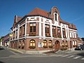 Town hall
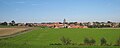 View of Boeschepe from the south
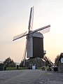 The Ondankmeulen (unthankfullness windmill)


Wikimedia Commons has media related to Boeschepe.