Beit HaShita (Hebrew: בֵּית הַשִּׁטָּה, lit. House of the Acacia) is a kibbutz in northern Israel, under the jurisdiction of Gilboa Regional Council. As of 2022 it had a population of 1,275.[2]
Beit HaShita בֵּית הַשִּׁטָּה | |
|---|---|
 Beit HaShita | |
| Etymology: House of the Acacia | |
 Beit HaShita  Beit HaShita | |
| Coordinates: 32°33′15″N 35°26′15″E / 32.55417°N 35.43750°E | |
| Country | |
| District | Northern |
| Council | Gilboa |
| Affiliation | Kibbutz Movement |
| Founded | 12 December 1935[1] |
| Founded by | Kvutzat HaHugim-HaMahanot HaOlim members |
| Population (2022)[2] | 1,275 |
| Website | www.beithashita.org.il |
Geography
The built-up area of Beit Hashita ranges from 70 meters below sea level to sea level.[3]
History
Source:[4]
Ceramics and coins from the Byzantine era were found in the region of Beit Hashita.[5]
The kibbutz traces its origin to a group meeting held in Hadera in 1928, by "Kvuzat HaHugim" of the HaMahanot HaOlim movement from Haifa and Jerusalem.[6] The first members lived at nearby Ein Harod until 1934, when establishment of the kibbutz began at its present location about 1 km east of Shatta.[6]
The land of the kibbutz was purchased by the Palestine Land Development Company from its Arab owners in 1931.[7][8] In 2015, a grandchild of kibbutz residents, Jasmine Donahaye, published Losing Israel in which she expressed her disillusionment on learning of the eviction of Arabs on the founding of the kibbutz.[9]
The kibbutz was later named after the biblical town Beit Hashita, where the Midianites fled after being beaten by Gideon (Judges 7:22),[10][11] thought to be located where Shatta was. It falls under the jurisdiction of Gilboa Regional Council.
In the 1945 statistics, Beit hash Shitta had 590 inhabitants, all Jews. It was noted that Shatta was an alternative name.[12][13]
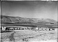 Beit HaShita 1940
 Beit HaShita 1940
 Beit HaShita 1945
 Palmach camp at Beit HaShita, 1947
.-JNF045560.jpeg)
.-JNF045559.jpeg)


Post-1948
In 1948, Beit HaShita took over 5,400 dunams of land from the newly depopulated Arab villages of Yubla and Al-Murassas.[14]
Eleven kibbutz members fell during the 1973 Yom Kippur War, the largest number as a percentage of the population than any other town in Israel.[15]
Economy
Beit Hashita produced cotton, wheat, melons, olives and citrus fruits. There was also a dairy barn, chickens and a fish farm. In the 1960s, Beit HaShita established a pickling factory which produces and markets pickles, olives and pickled vegetables under the brand name Beit HaShita.[16] The factory also produces syrups for making juices under the brand name Vitaminchick. The factory was bought from the kibbutz in 1998 by the Israeli food manufacturer, Osem.[17]
Religion and culture
The Kibbutz Institute for Holidays and Jewish Culture, an organization that preserves the cultural heritage of the kibbutz, was established by kibbutz member Aryeh Ben-Gurion, nephew of Israeli Prime Minister David Ben-Gurion.[18] Beit Hashita served as the basis for the 1981 English language book Kibbutz Makom, which described the kibbutz society.[19] Many of the member families of the kibbutz are secular.[citation needed] There is however a small orthodox synagogue.[citation needed]
Notable people
References
Bibliography
- Barron, J.B., ed. (1923). Palestine: Report and General Abstracts of the Census of 1922. Government of Palestine.
- Conder, C.R.; Kitchener, H.H. (1882). The Survey of Western Palestine: Memoirs of the Topography, Orography, Hydrography, and Archaeology. Vol. 2. London: Committee of the Palestine Exploration Fund.
- Dauphin, C. (1998). La Palestine byzantine, Peuplement et Populations. BAR International Series 726 (in French). Vol. III : Catalogue. Oxford: Archeopress. ISBN 0860549054.
- Department of Statistics (1945). Village Statistics, April, 1945. Government of Palestine.
- Donahaye, Jasmine (2015). Losing Israel. Seren Books. ISBN 978-1781722527.
- Fischbach, Michael R. (2012). Records of dispossession: Palestinian refugee property and the Arab–Israeli conflict (Illustrated ed.). Columbia University Press. ISBN 978-0-231-12978-7.
- Guérin, V. (1874). Description Géographique Historique et Archéologique de la Palestine (in French). Vol. 2: Samarie, pt. 1. Paris: L'Imprimerie Nationale.
- Kark, R. (1997). "Mamlūk and Ottoman Cadastral Surveys and Early Mapping of Landed Properties in Palestine". Agricultural History. 71 (1): 46–70.
- Karmon, Y. (1960). "An Analysis of Jacotin's Map of Palestine" (PDF). Israel Exploration Journal. 10 (3, 4): 155–173, 244–253. Archived from the original (PDF) on 2019-12-22. Retrieved 2015-11-27.
- Hadawi, S. (1970). Village Statistics of 1945: A Classification of Land and Area ownership in Palestine. Palestine Liberation Organization Research Center.
- Lieblich, A. (1981). Kibbutz Makom: Report From an Israeli kibbutz. Pantheon Books. ISBN 0-394-50724-X.
- Mills, E., ed. (1932). Census of Palestine 1931. Population of Villages, Towns and Administrative Areas. Jerusalem: Government of Palestine.
- Palmer, E.H. (1881). The Survey of Western Palestine: Arabic and English Name Lists Collected During the Survey by Lieutenants Conder and Kitchener, R. E. Transliterated and Explained by E.H. Palmer. Committee of the Palestine Exploration Fund.
- Robinson, E.; Smith, E. (1841). Biblical Researches in Palestine, Mount Sinai and Arabia Petraea: A Journal of Travels in the year 1838. Vol. 3. Boston: Crocker & Brewster.
- Robinson, E.; Smith, E. (1856). Later Biblical Researches in Palestine and adjacent regions: A Journal of Travels in the year 1852. London: John Murray.
- State of Israel (1952). Government Year-book (English ed.).
- Stein, K. (1984). The Land Question in Palestine. University of North Carolina Press. ISBN 978-0-8078-4178-5.
External links
- Official website
- Survey of Western Palestine, map 9: IAA, Wikimedia commons
- Kibbutz Beit HaShita Collection on the Digital collections of Younes and Soraya Nazarian Library, University of Haifa