Payl:Outer Hebrides UK location map.svg

Size of this PNG preview of this SVG file: 456 x 600 ka mga piksel. Uban pang mga resoluyon: 182 x 240 ka mga piksel | 365 x 480 ka mga piksel | 584 x 768 ka mga piksel | 779 x 1,024 ka mga piksel | 1,557 x 2,048 ka mga piksel | 1,083 x 1,424 ka mga piksel.
Tibuok resolusyon (SVG nga payl, nominally 1,083 × 1,424 pixels, size sa payl: 3.25 MB)
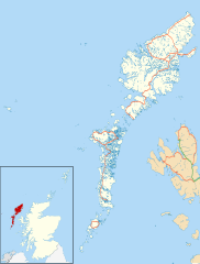
| Deskripsyon | Blank map of the Outer Hebrides (excluding Sula Sgeir), UK with the following information shown:
Equirectangular map projection on WGS 84 datum, with N/S stretched 180% Geographic limits:
|
| Petsa | |
| Gigikanan |
|
| Tagsulat | Nilfanion, created using Ordnance Survey data |
| Pagtugot (Paggamit pag-usab niini nga file) | This file is licensed under the Creative Commons Attribution-Share Alike 3.0 Unported license. Attribution: Contains Ordnance Survey data © Crown copyright and database right
|
| Other versions | File:Outer Hebrides UK blank map.svg - Blank map |
Kaagi sa payl
I-klik ang petsa/oras aron makit-an ang hulagway sa payl niadtong panahona.
| Petsa/Takna | Thumbnail | Mga dimensyon | Tiggamit | Komento | |
|---|---|---|---|---|---|
| kasamtangan | 20:23, 26 Septiyembre 2010 | | 1,083 × 1,424 (3.25 MB) | Nilfanion | {{Information |Description=Blank map of the Outer Hebrides (excluding Sula Sgeir), UK with the following information shown: *Administrative borders *Coastline, lakes and rivers *Roads and railways *Urban areas Equire |
Mga paggamit sa payl
Ang mosunod nga mga panid misumpay niining payl:
Global nga paggamit sa payl
Kining ubang wiki naggamit ning maong payl:
- Paggamit sa ar.wikipedia.org
- Paggamit sa bg.wikipedia.org
- Paggamit sa de.wikipedia.org
- Paggamit sa en.wikipedia.org
- Outer Hebrides
- Stornoway Airport
- Lochboisdale
- Daliburgh
- Callanish
- Stornoway
- Kisimul Castle
- Uig, Lewis
- Rodel
- RRH Benbecula
- Leverburgh
- Castlebay
- Balivanich
- Cladh Hallan
- Back, Lewis
- Knock, Isle of Lewis
- Ardmore, Barra
- Ness, Lewis
- Barra Airport
- Portnaguran
- Aignish
- Dun Carloway
- Shawbost
- Gravir
- Barvas
- Garenin
- Achmore, Lewis
- Aird, Lewis
- Ardhasaig
- Balallan
- Bragar
- Lochmaddy
- Hushinish
- Carloway
- Tarbert, Harris
- Benbecula Airport
- Northbay
- Sollas
- Howmore
- Carinish
View more global usage of this file.
🔥 Top keywords: Unang PanidPorn hubKategoriyaEspesyal:PangitaTabang:Mga sulodWikipedia:Mga pagpasabotIkaduhang Gubat KalibotanonPornograpiyaEspesyal:Bag-ongGiusabWikipedia:TubaanGajraj Bahadur NagarRío PichiloEspesyal:AkongHisgotContactTabangQáqaqWikipedyaWikipedia:Mahitungod sa WikipedyaRosaryoWikipedia:Maayong pag-abot, higala!DindoriRepublika sa KonggoWikipedya:TabangPornhubWikipedia:Talaan sa sulodTuaiWikipedia:Mga panghitabo800Passer melanurusParthenocissus vitaceaTraci LordsCadmiumFulton County (kondado sa Tinipong Bansa, New York)Gobolka Woqooyi GalbeedAnimasyonNaked BoyNeauphle-le-VieuxFutai-damuPakighilawas